Friday morning, we called for a tracking number for our credit cards. Contrary to the info yesterday, they said it still hadn't gone to a courier, so there would be no tracking number until Saturday, or maybe Monday. We headed south to Organ Pipe National Monuments Twin Peaks Campground to do the Victoria Mine Trail. The trail heads westerly across several ridges, before meeting up with the trail to Senita Basin, where it turned left to the mine. 2.2 miles each way.
 |
| Victoria Mine store |
When we got back to the highway, we headed to Lukeville, on the Mexican border to see what was there. The only thing we saw was the Gringo Pass RV Park, a gas station, and the border crossing. Then we returned toward Ajo, stopping at the Ajo Mountain wayside tables. Here we read the signs regarding the fact that this area is one of 47 United Nations Biosphere Reserves in the USA, 621 in the world .
 |
| hills west of Organ Pipe |
Further north we stopped at the WhyNot Travel Center in Why, about 10 miles south of Ajo, and picked up treats. Joan had her usual drumstick, but John noticed a rum raisin flavored frozen Coolstix. It was a bit of a challenge to open the tight plastic wrapper. Fortunately the cashier had given us napkins, so we could hold it while John ripped the top of with his teeth enough that the treat could be squeezed upward. Surprisingly, it had a decent rum raisin flavor.
Saturday, we walked down to the market at the historic plaza, where we bought a nice loaf of wheat bread. Then we walked north along the east edge of town, past the cemetery before we got to a cross road. It didn't go far enough west to the highway, so we retraced our route back a bit. Back at the highway, we couldn't see the IGA where the web said it was, so we looked in a couple of dollar stores for our iced coffee brand, with no luck. Back at the trailer, we chatted with the host, who told us the IGA had been moved about a mile north, so after lunch, we walked there. We did find one of the flavors of our brand.
Sunday morning we walked about a mile up the hill beside the RV park, to the beginning of the scenic loop road around the mine, which we had done the last time we were here, on a day trip.
 |
| rescue burro |
The rest of the day we watched curling from Vegas, NFL playoffs and some tennis.
We saw the 'blood' moon eclipse about 10:30 PM .
We got out early Monday morning to drive the scenic loop route to a spot near the Cowpie Rocks. From there, we followed BLM roads on a route called 'Old Faithful', just over 3 miles. Along the way we saw a water tank, a couple of small rodents scampering across the road, a hummingbird sipping on octolli flowers. There are lots of people boondocking in this area south of town, and west of the mine.
On Tuesday, we walked over to a little town park with about 4 pieces of basic fitness equipment. The signs describing the equipment were in better shape than the equipment. From there, we walked over to the Cabeza Prieta Visitor Center, which is closed due to the Fed Gov budget issue. We walked around the center, and read the signs outside.
Wednesday, the manager phoned us to say our credit cards had arrived. After picking them up and getting the cards activated, we drove out to the Ajo Regional Park northeast of town to check out a campground next to an equestrian center, i.e. rodeo ground. There is no water or sewer, and no charge, very large level sites so it wouldn't be a bad place to dry camp.
In the afternoon, we walked the mile and a bit north to the Ajo Historical Society Museum. A pretty good museum for a place this size.
 |
| Ajo Historical Society Museum |
 |
| New Cornelia Mine pit |
 |
| colorful decorating |
 |
| Ajo or Bust mural |
Thursday we returned to the same place we parked on Monday, to do a counter-clockwise loop around North Ajo Peak, a 5.3 mile trail on BLM roads.
 |
| North Ajo Peak from the north side |
 |
| phainopepla |
 |
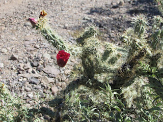
| flower on staghorn cholla |
 |
| little purple flowers |
No comments:
Post a Comment