Friday was our day to explore the area from the Trail of Tears Park. Our objective for the day was Cairo, Illinois. We crossed the Mississippi at Cape Girardeau, crossing the Bill Emerson Memorial Bridge.
We the took highway 3 in Illinois along the river, stopping at sites along the river, mostly describing the history of the Lewis and Clark expeditions. This was the first place on this trip that we have seen levees beside the River. We finally arrived at Cairo, near the confluence of the Ohio and Mississippi Rivers.
We decided to stop at Fort Defiance Park, right at the confluence, to eat the lunch we brought with us. We were disappointed, as the only feature in the park, besides parking, was an observation platform, with views of the rivers through the trees.
 |
| View up the Ohio River |
We returned to the State Park back on the Missouri side of the river.
We drove through Charleston, a beautiful little town that has to be designed after the antebellem houses in the New Orleans area. We stopped in Cape Girardeau which has amazing murals of the areas history on both sides of a two block long wall along the waterfront as well as a amphitheater that faces the Mississippi River. A unique and interesting site.
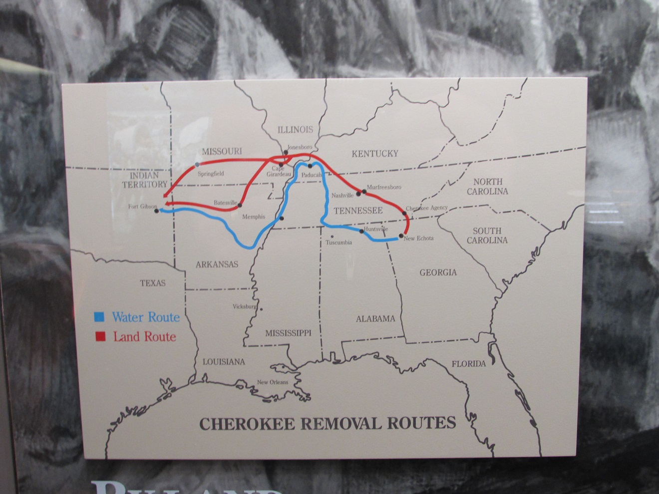
Saturday the Trail of Tears State park museum was open. We caught up on the history of this area and how poorly the Cherokee nation where treated and how difficult their trek was in 1838-39.
We also did two short hikes in the park, an nature trail at the visitor center and then a trail to a scenic overlook. We concluded that it was the best views we have had of the river to date.
Sunday we wandered down to the boat dock and then scrambled across an area that has been diked in order to provide the boat docks. It gave us up close sights of the river and was a great example of how the dikes have made the river accessible to boaters. Further up the river there were small dikes that provide calm waters for fishermen. Their main purpose was to keep the main flow of the river in the center to keep the channel deep enough for shipping. We also got a picture from the river back to the trailer.
We spoke to a fellow in the campground that fishes here all the time and says the fishing is great. The afternoon was spent watching the Nascar race.
Monday morning we packed up heading down to Cape Girardeau crossing the Mississippi River to Illinois to Cairo again,
then across the Ohio River into Kentucky, through Wickcliffe,
and finally arriving into Tennessee. Shortly after lunch we arrived at Reelfoot Lake State Park, found a campsite that met our requirements, and were told by the park maintenance people that the office will open at 9:00 A.M tomorrow when we will be able to pay our fees. Good news we are finally officially south (in our minds). The water is on in the campgrounds and we are hearing a lot of
" have a good day y'all".
After lunch we drove to the park visitor center, picked up some information about the park and did the boardwalk trail at the center.
We got some information about the Cypress trees, the snakes, frogs, eagles and owls that make this area home. Reelfoot Lake was a favorite site for Audubon and is a winter habitat for migrating birds. There is an injured raptor program there with some eagles, owls and several other birds recovering.
The lake was created by the New Madrid earthquake in 1811. Since then, it was regularly refreshed by floods from the Mississippi, until the levees were built to control the flooding.
Tuesday morning we payed our camping fees 22.95 for 2 nights, power and water with good bathrooms and free clean showers, 50% off the regular rate because Tennessee gives seniors a big discount. We then headed off to do the scenic drive around Reelfoot Lake. Our first hike was at Keystone Pocket, an interesting hike along the lakes edge about 2 miles round trip.
 |
|
We then headed to the Air Park and completed another 2 mile hike, wandered through the campground there that we didn't know even existed. It was really nice, and although it had good trees, it had clear views for satellite. And, it was totally empty, even though it was open. The next point of interest was a waterfowl refuge observation tower, but it was being painted, so was closed.We then stopped at the Long Point Refuge Observation towers. A bit of a bust for birds or animals, but a nice bench in the sun on which to have lunch. After being refueled we did the Grassy Island Auto tour. We discovered a great interpretive trail that was a mile long and had interpretive signs along the way. The next observation tower was a real great stop, lots of waterbirds, plants.
 |
|
On the way back to the trailer we stopped for diesel and Joan had the pleasure of trying to use her US credit card in a chip machine for the first time, so of course she couldn't remember her pin. Oh well cash still works. That service station is very progressive, despite being in a very small town, but we expect this is a one off.
Wednesday morning we packed up early. After a quick coffee we made a quick trip into Dyersburg, Tennessee to Mel's Diner for breakfast. We had checked the area out on google maps and determined that we could park a couple of blocks away at the recreation center. We talked to the town employees who said parking there was fine, particularly since it was Veterans' Day, and most people had the day off. Mel's Diner was small and packed with locals. If there were 2 spare seats at a table just sit down and visit with the others at the table. Are you from around here a few people asked, like after a few words of our relative accents, there was any doubt. They were amazed that we had traveled this far, but when we explained we had a desire to avoid snow they completely understood. One gentleman sitting next to us said there had been snow here a couple of times in his lifetime (he made us look young). It was a good choice for a breakfast place. John had a 1/2 slice of ham and eggs and Joan her usual western omelet. A very substantial and delicious breakfast. We just had to eat there as it reminded us of Mel's Diner of 70's sitcom fame, but no redheaded Flo as waitress. We then headed off to our destination of Tom Sawyer RV Park in West Memphis, on the Arkansas side of the river. We did make a stop at the Arkansas visitor center to pick up information and we arrived at the RV park just before 1:00 P.M. This place seems ok, decent wi-fi, a perfect site, overlooking the Mississippi river from which we can see downtown Memphis, and, as an extra bonus, complementary laundry. We were glad we had arrived early in the afternoon because a storm blew in shortly after we got set up, driving in the wind would have been very unpleasant. The park is quite nice, but it is interesting that we had to drive over the levee, as the park is between the river and the levee. The fellow who directed us to our site in the 5th wheel section (so named because the utilities are oriented so the back and side windows get river views) told us the park had flooded a couple of times this year, the last in July. The laundry is located in the second story above the bathhouse. There is a sign on the wall of the building showing that the flood of May 2011 reached part way up the second story of the building. Sounds like autumn is a good time to be here, not just because of the leaf colors.
 |
|
Thursday morning our first stop was Costco. We then headed into Mississippi, the state, to go to a Welcome Center to pick up info for the Natchez Trail, Mississippi RV parks, historic site and hiking opportunities. After a quick picnic at the Welcome Center we did what was supposed to be a scenic drive along the River from Hernando to Coldwater, Tunica and Lula (which was the home of legendary blues performers Charley Patton, Son House, Frank Frost and Sam Carr. Patton immortalized Lula in a couple of songs from 1930 and 1934). The best part of the trip was the treed rolling country between Coldwater and Tunica. The area from Tunica south along the river is Missippi flood plain, which is extremely flat agricultural land.
We then crossed the River again, and returned to the park through Arkansas.


No comments:
Post a Comment