Friday morning at breakfast we had a nice chat with a couple from Lynden, Washington, just south of Langley, BC. About 10 AM, we walked over to the beach, and waded along the edge of the ocean north to St. Augustine Beach Pier. We saw an osprey with a fish in its talons heading for its perch. Lots of shorebirds.
 |
| Terns |
We thought about having lunch on the pier, but like a lot of places here, the pier is private. $2 each to go out on it so we sat on the seawall to eat. Immediately about 5 birds started looking for handouts. Then we walked back along the road going by our hotel.
 |
| St. Augustine Beach Pier |
On the way back to the hotel we saw a hawk perched on a power line looking for lunch.
 |
| Hawk |
On Saturday we drove west in the rain toward Tallahassee. Really pouring in Lake City, then it would ease off considerably. We stopped at Busy Bee Travel stop along the way. It is similar to Buc-ee's, our favourite Texas gas stops. We picked up coffee, selecting a dark roast and a pecan, from several flavors available, and Bee-licious White Cheddar Ranch Popcorn, also from several flavors. It lived up to its name. A while later we crossed the Suwanee River, famous in the Stephen Foster song written in 1851. In 1935, it became the state song of Florida. Flash flood warnings for Tallahassee. By the time we got to the hotel, it had been augmented with a tornado watch. Fortunately, we didn't see any direct affect.
Sunday morning, there were thunderstorms, which took out half the cable service in Tallahassee, including ours. After some discussion, we decided it was worth trying to drive out to St. Marks Lighthouse in the St. Marks National Wildlife Refuge, where there are a lot of hiking trails, including the Florida Scenic Hiking Trail, which goes through the refuge.
 |
| Pine and Palmettos |
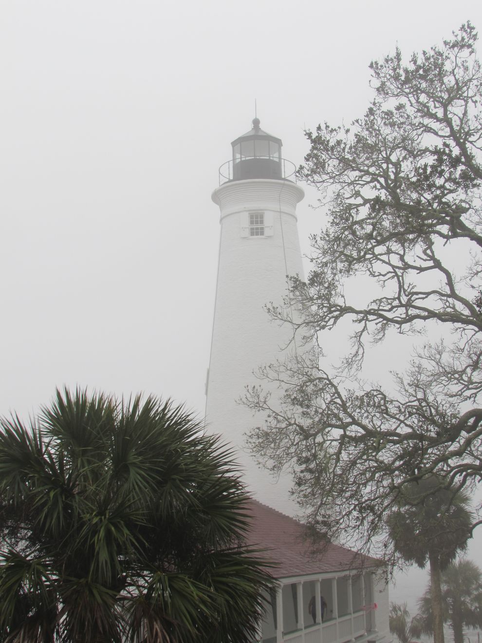
There were a few times when it looked like huge buckets of rain were being dumped down, but we perservered. By the time we got to the lighthouse, it was raining lightly, so John dug out a light plastic poncho (which we have rarely, if ever, used) to at least have a place to hide the camera.
 |
| St. Marks Lighthouse |
|
We got lucky as the rain stopped shortly. We did about a mile walk around the Lighthouse Pool. We saw cormorants, pelicans, snowy egrets, various ducks, herons which we spooked. On the drive back to the visitor center, we saw some bufflehead ducks, an antlered deer.
 |
| Cormorants |
 |
| Pelicans in flight |
 |
| Pelican preening |
 |
| Heron |
 |
| St. Marks Lighthouse |
 |
| Deer | |
We also saw signs warning about bears, but we didn't see any of them. The visitor center gift shop had a good selection of wildlife themed t-shirts. Joan picked up a nice one with a cougar, alligator, egret and eagles. North of the visitor center, we saw 3 more deer, probably a doe and two young ones.
Then we drove southwest to the small towns of Panacea and Sopchoppy, just due to their rather unique names, before returning to Tallahassee.
In the evening, there was another thunderstorm. One particularly loud strike resulted in a power outage. An hour or so later, the power came back on.
Monday morning turned out to be reasonably clear, as we headed west. We were surprised to see more huge solar fields along the way. We don't think of north Florida as sunny. We started seeing lots of broken trees along the highway, interestingly most of them broken halfway up the trunk.
 |
| Trees broken by hurricane Michael |
.Remnants of hurricane Michael. On the east side of Mobile Bay, we stopped at a Rand McNalley Editors historic pick called Spanish Fort Overlook. During the revolutionary war, France, Spain, Britain and the USA were interested in this area. The Spanish captured Mobile, and built a fort here to protect the area from the British in Pensacola. The British attacked the fort, but were held off by the Spanish. A few months later, the Spanish took Pensacola, which expelled the British from the Gulf Coast. Then we crossed the bay to Mobile, going through another tunnel.
 |
| Mobile, Alabama skyline |
|
40 miles west of Mobile, just across the border into Mississippi, we arrived at our next hotel in Moss Point.
Tuesday, we drove out to the Grand Bay National Estuarine Research Reserve. We were surprised to see eagles nests on the big power lines.
 |
| Eagles nest |
The highlight was the visitor center with descriptions of how an estuary mixing fresh water and salt water creates biodiversity. It covered the history of European impact on the area. Before Europeans, the savanna covered 3/4 of the Southeastern Coastal Plain. Now, they cover only 5%. They had a Mississippi diamondback terrapin named Tobi in the visitor center.
 |
| Tobi the diamondback terrapin |
We were disappointed in the hiking. We did a 1000 foot walk along a boardwalk at the center. Further south, we did a half mile loop on a birding trail.
 |
| tree along birding trail |
We heard a couple of birds but didn't see any, which was surprising, because when we drove past earlier, we saw a red bird flying into a bush.
When we returned to town, we headed to a shopping mall about 15 miles west in Gautier. It used to have 3 department stores, Sears, JC Penney and Belk. The only one left was Belk. The mall was demolished, except for the one store in 2014 to prepare for a new development. The only evidence there had been other stores was the amount of parking. The buildings were gone. We were done early enough to go to the Ruby Tuesday restaurant next to our hotel for lunch. It had an extensive salad bar for Joan, and John enjoyed a nice steak. This was our first visit to this chain.
Wednesday morning, we planned a roadside attraction trip from Moss Point to Baton Rouge, since it is only about 2.5 hour trip.
We added an extra stop almost immediately, as we saw the directions to the Mississippi Sandhill Crane National Wildlife Refuge https://www.fws.gov/refuge/mississippi_sandhill_crane/. We arrived before the visitor center opened, so did the 3/4 mile loop through the savanna, along an edge overlooking a marsh. They had lots of little signs along the way identifying various flowering plants. Few of them were open, as it was just above freezing (there was a good layer of frost on the truck windshield that pretty much melted by the time we left). Unfortunately no sandhill cranes, and few other birds.
 |
| longleaf pine tree in sapling stage |
A lot of the roadside attractions were along the coast west of us from Ocean Springs through Biloxi, Long Beach. The first one was the
'crooked feather Indian head'.
 |
| Crooked Feather |
Then the
Hurricane Katrina Memorial in Biloxi, showing the height of the tidal surge. We had a bit of trouble finding this, as the address on the roadside website was about a block further away from the beach.
 |
| Hurricane Katrina Memorial |
Nice long white sand beach all the way along the coast through this area. Beautiful old houses facing the Gulf. Lots of historic plaques along the road.
We missed the
'big pig on a station wagon' , but couldn't be bothered to return to it, but had seen the
32 foot high shark head entrance on the way by.
 |
| giant shark's head |
The next stop was
Beauvoir, the home of Jefferson Davis, president of the Confederate States. We just took a few pictures there.
 |
| Beaurevoir - Jefferson Davis home |
In Long Beach, we found
the Friendship Oak tree on the campus of University of Southern Mississippi Gulf Park. It is over 500 years old. The legend is that 'those who enter my shadow are supposed to remain friends through their lifetime' no matter where fate may take them in after years.
 |
| Friendship Tree |
There was a long strip of white sand beach along the Mississippi state section of the gulf coast.
 |
| white sand beaches |
From there, we crossed into Louisianna at Slidell. This was the furthest attraction from our route, and the least attractive of them. It was located in an abandoned service station, which did give us room to pull off for photos.
 |
| catfish |
On our drive through Slidell, we followed a mini-van with the worst shock absorbers we have ever noticed. Every time it hit a bump in the road, the back end would bounce high, and then continue bouncing for at least half a block after a good bump. Wouldn't have wanted to be the seasick kid riding in the back of that van.
Our next stop was the
Ronald Regan statue north of I-12 in Covington. We only had a rough address there, so had to check the instructions in detail to find it. . There was a group of musicians jamming in the bandshell in the corner of the park, with the statue facing them.
 |
| Ronald Reagan statue |
Our last attraction for the day was in the center of the town of Pontchatoula. An alligator called
'Old Hardhide' is in a fine wired cage. The first 'Ole Hardhide' was blind in one eye. When it died in 1985 thousands of people gathered in the area to pay tribute. His coffin was carried on a horse-drawn wagon to his resting place south of the city. There have been several gators over the years since then.
 |
| Ole Hardsides |
|
We finally arrived at our hotel on the east side of Baton Rouge about 3:00, having taken about 7 hours to do the 2.5 hour route between the two hotels.
Thursday, we drove to the Mississippi River south of downtown Baton Rouge to do a hike, but couldn't find the parking area for a 1.5 mile loop along the river. Where we thought the trailhead was located, there was a sign saying 'no motorized vehicles'. It turned out we had gone past the turn to the parking lot (which we didn't discover until we looked at the info when we arrived at our next hotel).
We headed west toward the Atchafalaya National Wildlife Refuge. We set the GPS to go to a little town at the north end of the Refuge. After going past a couple of exits, it directed us onto the road through the refuge, along the Atchafalaya River. We had suspected it might be gravel, but we have the have the gps set to avoid dirt roads, so we figured we would have a paved road. It turned out to be what looked like it used to be paved, but was broken down to gravel. The road went past a lot of 'camps' along the river. We got a few glimpses through them to the river. Further on, there was a levee between the road and the river, so we didn't get to see anything special. About 5 miles out of the 17 across to the next highway, the gps warned us that there was 3.4 miles of dirt road on the route. So much for avoiding dirt roads. The road was pretty consistent all the way through, dusty, a bit narrow, but we did meet a few trucks of hunters along the way without incident. About halfway across we came to a camping area on top of the levee with several tents in it. There were permits for camping that listed the animals that could be hunted. There was also a warning that bears look a lot like boars at a distance. Bears are protected in Louisianna.
Once we got on highway 190 heading west, we saw an ad for jalapeno sausage cheese bread at Bourque's Market. We stopped there and picked up a large tart size, the smallest they had, and a pumpkin spice tart for lunch. We carried on west on 190 until the town of Eunice. From Eunice, we headed cross-country on several levels of local highways until we got to the town of Deridder, our stop for the day. The area west of the Atchafalaya is more agricultural, with herds of cows and hay fields in clearings, and some logging. Quite different from the coastal areas we have been travelling through this week.


No comments:
Post a Comment