Friday, we watched Gushue and Edin in the morning. By the time that was over, it was too hot to walk any distance. We couldn't believe how many units came in around dark to dry camp in the area.
Saturday, we got away fairly early because there was a wind warning starting at noon and going to 10pm. We headed north up highway 93. Our first stop was a marker for the old boundary between Utah, Nevada and New Mexico. In 1850, as part of the provisions for organizing the land ceded by Mexico in 1848, the 37th parallel was the boundary between the territories of Utah and New Mexico. When the territory of Nevada was formed, from western Utah, this remained the southern border until 1867, when the Colorado River became the border on the southeast part of the state.
Further on we drove through the Pahranagat Wildlife area. The valley here has lots of water, so some different plant forms. Further north, we stopped at Alamo for a break, and to read a historical marker about the valley. North of Alamo, the highway heads east towards Caliente, across the Delamar Valley, which has a Joshua Tree forest,
then over the Delamar Mountains at Oak Springs Summit (6237 ft) covered with conifer trees,
then down Newman Canyon into Caliente (4398 ft, 1200 pop).
We made it before the winds came. Although there was some wind in the afternoon, it seems pretty sheltered here. We paid for 5 nights in Young's RV Park. It's been a while since we were this close to the train line.
Sunday we did a walk around town, about 3 miles. The cherry trees are in full bloom.
The town was a division point for the railroad until the diesel engine era, and had a large population during its construction. It is also subject to heavy flooding, with two valleys converging here. When there is a large snowpack and heavy spring rains, a lot of water flows through the area. The rail lines had to be repaired almost yearly from 1906, particularly in 1910. In 1911, the tracks were moved higher above the valley floor.
It is a bit unusual here that the railway is in a different valley than the
highway. The railway route is too narrow to accommodate a highway as well.
The town is divided by the UP tracks, with one crossing at the north end of town, and another where SR317 goes under the tracks past the south end. A train heading south stopped shortly after we started going north. By the time we go to the crossing at the north end of town, the northbound train that the first one was waiting for, blocked us from crossing the tracks for a few minutes. We stopped at the grocery store to pick up a few things. Then we looked at the Union Pacific Depot, built in 1923 (after a previous one burned down).
 |
| Union Pacific Depot |
|
Then next highlight was a pig farm with woolly pigs. The only reference we could find to woolly pigs is Mangalica, or Mangalitsa, Hungarian pigs.
In the afternoon, we watched the NASCAR race and then in the evening, watched the Gold Medal Men's Curling Championship.
Monday, we did a drive down SR 317 from Caliente to Elgin Schoolhouse. We got just past the state park, which we were going to visit on the way back, and saw a road closed sign. We checked with the ranger at the state park, and found out the construction was finished, but the sign hadn't been taken down. SR 317 goes through 'Rainbow Canyon'. There were interesting colors in the hills.
On the way, we came upon a flock of turkeys at one of the ranches.
Elgin Schoolhouse is a State Park site, but isn't being manned at the moment, and the gate is locked. We were able to read the history, and take a few pictures.
 |
| Elgin Schoolhouse |
We returned to Kershaw-Ryan State Park ($5/vehicle). The campground there doesn't have power yet, so isn't an option for us. We did the 1.5 mi return hike up to an overlook.
 |
| Trail Map |
There are a few steep spots with loose dirt on them that made them sketchy. The views from the top were quite good.
Back at the trailhead, we did the short Rattlesnake Loop. It was covered in raspberry bushes, which were planted at the ranch that used to be here.
We chatted with a couple from Seattle who were on a week trip. They were camping at Cathedral Gorge SP, and recommended it. We had lunch at a table and watched the geckos enjoying the brick walls, and the catfish in a small pond with water circulating.
 |
| Geckos sunning |
Tuesday, we headed for the mining town of DeLamar (originally Ferguson) site of gold mining from 1893 to 1909. About 1500 people lived there. $25 million dollars of gold were produced here, making it the leading producer in Nevada around 1900.
To get there we headed west on highway 93 over Oak Springs Summit back into the next valley. Then we headed south on Pole Road, a good gravel road that follows the power line, then southeast toward the range of hills on Delamar Road. The main power line has an unusual pole structure, with poles wrapped in cable.
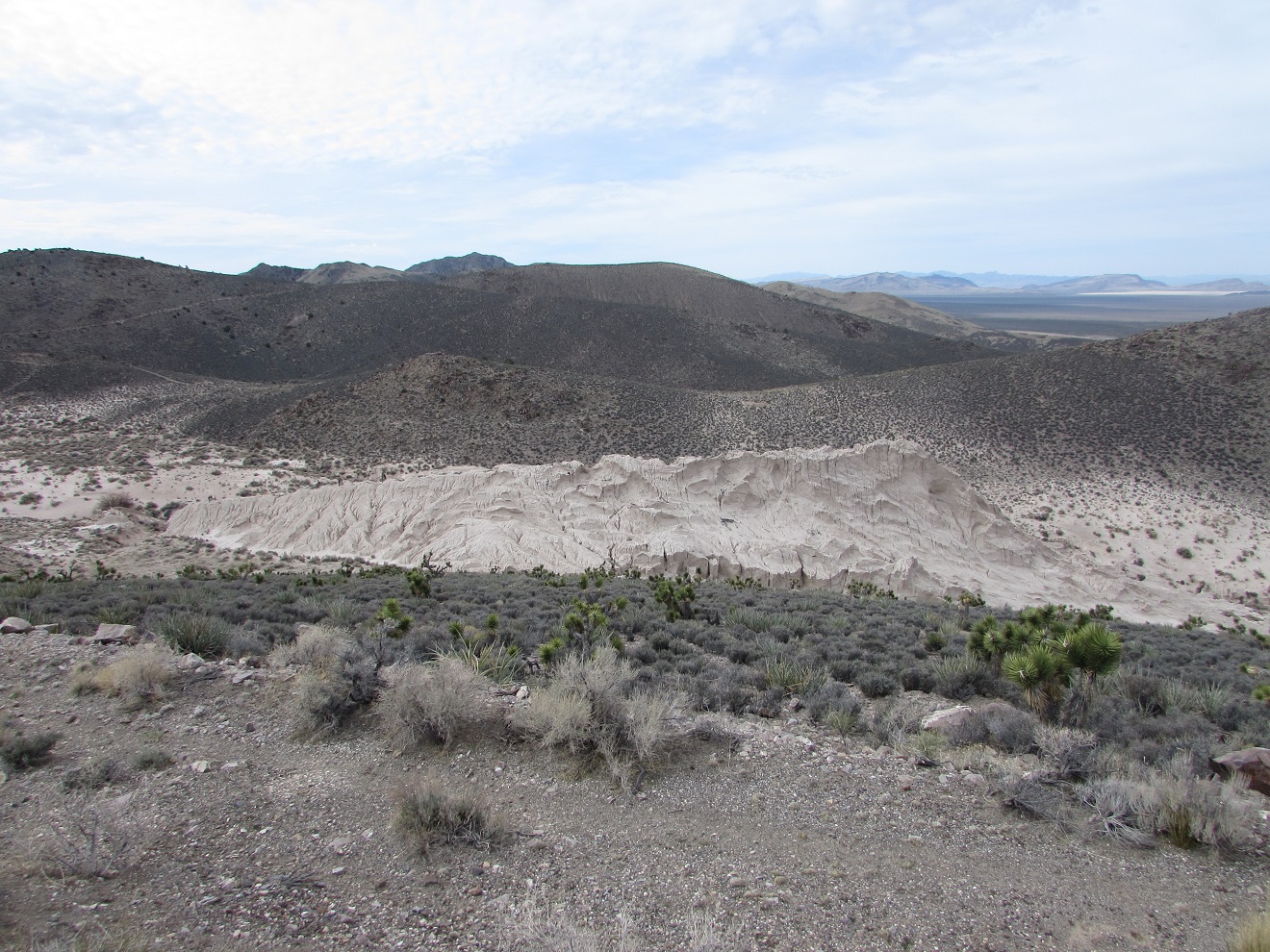
This road was good until we got to a cemetery on the edge of the hills. Then we drove about 2 miles up the side of the hills on a rough rocky track. About mile from the old town site, we decided we had punished the truck enough, and parked it where a side road went straight up over the hill. We walked down about a mile to the mining area. It is one of the most extensive sites (except the ones that have been commercialized into ghost town attractions) that we have seen. There are huge tailings piles, in a most unusual shape.
 |
| Tailings |
These were made by dry milling the process. Inhaling the dust from the milling caused the death of many of the workers. Consequently, the town had the nickname of 'widow maker'. The digs are high on the hill above the mill.
 |
| Digs above the mill area |
|
There are a lot of remains of stone buildings, some of them several stories high.
As we were heading back to the truck, we saw 5 jeeps slowing working down the hill on the far side of the valley.
When we got down off the hill, we stopped at the cemetery, which had about half a dozen marked graves.
On our way back, just before Oak Springs Summit, we stopped at the Oak Springs Trilobite site. There is a shale area here that the BLM has marked, put up signage, and created a nice rock lined trail to the shales. We think it has been pretty well picked over, but if you had the patience, you could find fossils. It's possible that the black pattern on the left might be a fossil, but we didn't find anything distinct.
Near the trail, we noticed a rare little horned toad.
 |
| Horned Toad trying to be invisible |
Wednesday, we did laundry and cleaned up the trailer to head north on Thursday. However, when we did a walk around the walking path in town, the wind came up. At one point, we had turn our backs to it so we didn't get sandblasted. We were planning on getting away early on Thursday because there were wind warning starting about noon, and we wanted to get to Wells before it got bad. When we got back to the trailer, and checked the weather, there were wind advisories here in the morning as well, so we paid for another night.
Thursday morning, the wind had gone down, so we thought we might have been hasty deciding not to travel.


No comments:
Post a Comment