Thursday 31 March 2016

Week ending Mar 31, 2016 Lake Mead National Rec Area to Idaho Falls

Friday afternoon, we drove to Costco in Henderson to look for Krusteaz pumpkin loaf mix.   We discovered that there is none in any Costco in Las Vegas area.    We looked at Sports Authority, then Dicks for  a hammock replacement with no luck.  After Dicks, we went into the attached mall, and happened to find a loveseat recliner  in a furniture store in the mall.  It was the right size, and the right price.  It even fit in the back of the truck.  We paid cash, so headed across the parking lot to the Bank of America to replace the cash.   There happened to be a manned Goodwill drop off location on the corner of the bank lot.  The fellow said that they would be thrilled to take our old glider and recliner even though they weren't spotless.  We hurried back to the trailer to put the new loveseat in the trailer, which fit with some space to spare.   Then we loaded the old furniture into the truck and returned to Goodwill.      Then we celebrated at Red Robin in the same mall.   Incredible how well this worked out.

Saturday was another windy day.  If this is typical we won't be doing more than an one-night stay here in the future.   We drove a few miles down the road to Callville Bay.  There are lots of houseboats for rent in the marina.   A new boat launch has been built to get down to the water, rather than extending previous launch.  The marina store was closed for the season, but the store at the top of ramp was open.  It had a few staples and souvenirs.   There is an RV park and rental cabins here as well.  
Houseboats for Rent

Old Boat Launch

Cinnamon Teal
The Colorado River valley here, before the Hoover Dam was built, was on one of routes of the Old Spanish Trail route from Sante Fe to California. 
Old Spanish Trail from Sante Fe to California
We returned to trailer to watch the women's world 3/4 game.  Then we packed up as much as we could in order to get going early Sunday morning.  In the afternoon, the Park Warden came through the camping area.  Shortly after that at least three units left.  We assume they must have exceeded the 15 day limit.

Sunday morning we just had to put stuff away which we used overnight,run in the slides, and put the trailer on the truck and headed east along the lake.  We replied to a Happy Easter message from Sue as we were traveling.    We got a few pictures of the red rocks toward the east end of Lake Mead near Overton Arm. 

Valley of Fire formations
We took a look at the 3 free camping areas near Overton.   One is well organized, right on the edge of town in the Overton Wildlife Mgmt Area.   One in the middle further south definitely had the most use.    We stopped at Walmart in Mesquite to pick up a box of wine before we hit Utah, then stopped in St George for diesel and muffins.   On our way to Fillmore, we drove over 3 summits around 6000 to 6500 feet.  Lots of snow capped mountains on this route, and some snow in the fields right by the road.  We figure it must be from the storm that blew through Salt Lake and Denver areas a few days ago.     We arrived at Wagons West RV Park in Fillmore about 1:45 pm.    The office is closed for Easter Sunday but they had provided a site number for us when we booked.  We had the satellite up and running just in time for the introductions of the final game of the World Womens' Curling.  There are a few cherry trees in the RV park, just blossoming.

Cherry Blossoms
 
On Monday walked about a mile south on  Fillmore's main street.  We passed a house made out of lava rock, with a very artistic lava fence.

Lava House
Lava Fence
We toured the Territorial Statehouse State Park Museum.   It is a nice museum for a $2. seniors entrance fee.  It has lots of information on the founding of Utah.  The Mormons originally planned on making it  independent of the USA and naming it the State of Deseret, the name of the beehive in the Book of Mormon.  However, the USA stopped that from happening, formed the state of Utah (named after the local Indian tribes, and made the capital here in Fillmore.    The State of Deseret was intended to encompass one sixth of the area of the continental USA.


The town was named after President Millard Fillmore, and the county was named Millard after him as well.  After a short time here, Brigham Young moved the legislature to Salt Lake City in protest.  The federal authorities relocated it back to Fillmore, but the members moved it back to Salt Lake almost immediately, where it has stayed since.   One of the features of the museum  was a hall of pictures of the pioneers in the area.

When we got back to the trailer, we got a propane tank refilled.  It was handy because they refill tanks right here in the park.

On Tuesday we decided to stay a couple more days because snow was forecast until  noon on Wednesday on the high spots between here and Idaho.  We spent the day doing laundry and cleaning the desert dust out of the trailer.


On Thursday, we drove north through Salt Lake City, Pocatello to Idaho Falls.   There were a few flakes of snow in the air between Fillmore and Salt Lake, a bit of rain south of Pocatello, but nothing significant.  There was quite a bit of snow in the fields, some of it pretty close to the highway.  We were passed by many western Canadian vehicles heading north.    We are only spending the night in Idaho Falls, so didn't bother unhooking the trailer from the truck.  John plans to watch Roanich's quarterfinal tennis match in Miami this evening.

Thursday 24 March 2016

Week ending Mar 24, 2016 Big Bend of the Colorado to Government Wash at Lake Mead

On Friday morning, a Roadrunner hopped up on our fire pit to pose for us.   We refilled our cash supply and did a bit of shopping that day in Bullhead City.

Saturday we went for breakfast at Harrah's before investing $20 in slot machines, and wound up doubling our money, so reduced our breakfast cost significantly.

On Sunday, we went for a short walk to the beach before spending the rest of day watching the NASCAR race, curling and Roanich playing the final against Djocovic at Indian Wells.  There was a great sunset in the evening.

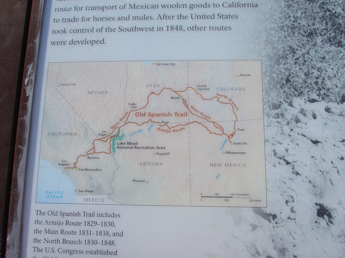
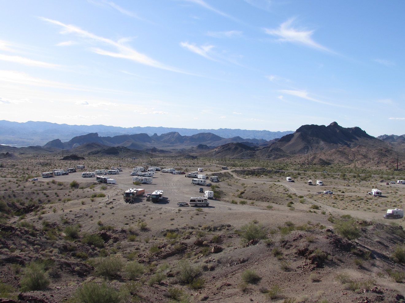
Monday morning,  as we were getting ready to move on, we saw a scorpion crawling on the ground next to the utility pad.  By the time we got the camera out, it had disappeared.  Too bad, since this is the first scorpion we have seen in the desert.   We think it might have a hole under the pad.  We headed north to Henderson to pick up some groceries and fill up with diesel before going to Lake Mead National Recreation Area.    We had found several promising spots on our 'free camping' website.  The first one in the area is at Government Wash on the north west side of Lake Mead.  There were lots of spots available.  As we were pondering the feasibility of a site which was a bit narrow, a large toy hauler was packing up nearby, so we snagged that site when they left.   There were some heavy winds in the evening and overnight.  We had been alerted to this when we checked the weather yesterday.   After listening to the wind howl for a while, we decide to bring in our solar panels.   This is the first time we have decided to do that.


We did have another nice sunset. 
On Tuesday morning, the wind eased up.  We took a walk down toward the lake, but didn't get to it.  The only route from that point was occupied by people in a tent, and we didn't want to walk through their site.

On our loop around back to the trailer, we chatted with a couple who stay here often, as their son works in Las Vegas.  The wind had broken the feet of their satellite tripod, for the first time in many years of trailering, and they had lost a tarp and a few small items.  We carried on to the boat launch ramp, which was closed in 2003, because the water level had dropped well below the boat ramp.    Based on Bureau of Reclamation numbers for each year from 1935 until 2015,  the lake started at 709 feet  in 1935, and increased every year to a level of 1180 feet in 1943.  The water level  The water level in the lake peaked at 1214 feet in 1998.   It rose and fell until it was down to 1087 in 1956, but went up to 1182 by 1959.   It hit a peak of 1214 in 1998.  It has dropped 125 feet since then with drops for 13 of the last 16 years until 2015.   The launch was closed in 2003.  It looks like they closed it when the water level went below 1150 feet.    Since the lake filled initially, it has only been below 1150 feet for 4 years in the 1950's, 6 years in the 1960's and every year since 2003.

We took a picture of the snow-capped mountain behind Lava Butte.   This is the first time we have seen  snow on the mountains since we hit the east side of Arizona.   It still meets our requirement of being too far away to touch 


The  wind picked up again around 11 am.  It wasn't quite as bad, but still annoying.


On Wednesday morning, the wind had dropped.   We went for a walk down through the middle of the area.  A fellow whose 2 young kids took their little dog walking down across a gully was concerned because the dog was off leash (not supposed to be).   We saw a dome of interesting crystal structures sort of like the calcite buildups at the north end of Yellowstone park.  However, there is no spring here now.  

Crystals zoomed


We carried on down to the cove.  There were a couple of fishermen in the personal flotation devices.  One fellow casting from the shore was looking for bass, but could only see some kind of shad.  A lot of fishermen drive through the camping area to get down to the lake since the boat launch is closed.   The water wasn't too cold to the touch, but not swimming temperatures. No problem for a grebe though. 

We walked up the north side of the cove, and carried around past a wash with some kind of ceremonial circle, with paths radiating out from it up the walls on both sides of the wash.
Ceremonial Ring?
Paths around the ring


Lake Mead

Further on there were a couple of RV's  parked on a road that comes in from the north. We can see them from our site across the valley.  It looks like this road could be an interesting place to park, as the road branches out many times up on the ridge that creates our cove.   Back down at the cove, there is lush greenery in the bottom of the wash as it nears the lake.  The plants continued into the lake, making a haven for lots of ducks.


Back at the trailer, we saw a couple of coyotes on a ridge between a couple of washes, about 50 feet from our trailer.   We had heard them singing the day before. 

Coyote
Thursday morning we heard the coyote chorus again.    We also saw what we think is a hawk about where the coyotes were yesterday.

Hawk?
After breakfast, we headed to the Park Visitor center to do the Historic Railroad Trail.  The trail was built in 1931 during the building of Hoover Dam to move materials up to the dam site.  5 tunnels were required on the 3.7 mile stretch.   The tunnels are unusually large, 18 feet wide and 27 feet tall, to handle the huge pieces of equipment to the dam site.   Some were reinforced with large timbers to prevent rocks from falling on rail cars and workers. The tunnels are also a sanctuary for bats, but the bats are only here in the summer.   
Tunnel
 There are great views of the lake from the trail. The shot below shows how far the the high water line below the black cap on the island is.  Compare it to the sailboat just in front of the island.

High water mark.

The trail is closed from June to September, because 'Heat Kills'.  We thought it might kill us one July when the kids were in Jr High and we parked our tent trailer in a hotel lot campground in Las Vegas on the way to Disneyland.  Even at night it was almost unbearable.


As we were posting the blog, we were watching the Womens' World Curling, and disappointed to see the Canadian team get thumped by Japan in 6 ends.

Thursday 17 March 2016

Week ending Mar 17, 2016 Lake Havasu to Big Bend of the Colorado (Nevada) State Rec Area

On Thursday, after posting the blog, we headed for Red Robin for lunch, but came across the Mudshark Brewery, and figured we would try a local restaurant instead of a chain. Decent food chicken wrap and bbq burger and good beer Scorpion Amber Ale and a Porter.   We then stopped and talked to AT&T, Verizon and Cricket(bought by AT&T) about options to T-mobile, since AT&T has best area coverage.  T-mobile is moving into the area. May get better coverage, but coverage is great in LHC, but drops off almost immediately. 

On Friday, after phoning  Dad we walked south then east up a wash canyon.  We caught up with a couple from Tappen BC (just north of Salmon Arm) and had a long chat.  They were out looking for gold with dousing rods (both of them had a set).   After returning to the trailer, we watched the rest of the last round robin games in the Brier.

a baby arch

interesting rock structure

Fault Line

the Lone Tree this wash is named after

a natural Inukshuk
Saturday morning  we just did a short walk.  Back at the trailer we talked to a fellow from Parksville.  More curling.
Gold Capped Sparrows
Sunday morning, we walked about 4 mile round trip up the south side of the wash heading up past the lone tree.  We heard some target shooting over the ridge to our left, with an occasional heavy sounding gun.  This may have been the source of  a .43 shell the people from Tappen mentioned when we talked to them yesterday.    In the afternoon, we enjoyed the NASCAR race and the Brier final.

On Monday,  walked the catchment loop for an hour.  We headed back to the library to do some research on our trip, and did a bit of shopping.   

Tuesday morning we got everything packed up.   The motor running the large slide was a bit sluggish, so we plugged into truck, and it went a bit easier.  Could be battery was a bit low.   We might have to use the generator a bit more often when we are on solar.  We did have a couple of cloudy days this week, but we still seemed to be getting pretty good amps during the day.  It could  also be that it took a more power to raise the front of the trailer on the slope we were on when we set up.    We drove to Big Bend of the Colorado State Rec Area just south of Laughlin, Nevada.  They only had 3 sites available, were full last night.  2 sites were back-ins with utilities on the wrong side.  The other site was a handicap reserved pull thru. However, they already had 2 handicap sites in use, so could let us have this one.    We couldn't pay today because the lady that does credit cards isn't here until tomorrow.   We saw 3 road runners and a couple of bunnies run through our site.

On Wednesday we walked to the entrance station to pay for 6 days.   It turns out that they just converted to the pin credit card system, so Joan's card wouldn't work.   As it happens, John's card has a 'pin failed' message on it too, so we wound up paying cash anyway.   Hopefully we won't run into any more pin machines before we get back home to get our pins fixed.  

After getting that sorted out we went for a walk through the scrub in the park, along the river.  We were amused  by Joan's comment that the trail through sandy areas was marked by tree 'crumbs' so we wouldn't get lost. 
Swift water along the Colorado
Tree 'Crumbs' marking the trail
Laughlin from the Rec Area
Thursday, we walked down to the beach at the day use area.  3 jet skis were being launched while we were there.   Back at the trailer, we are watched the end of the first round of the Elite 10 curling from Victoria, while posting the blog.  Fortunately, our T-mobile hotspot works very well here, since we are right across the river from Bullhead City in Arizona.

Big Bend of the Colorado  beach

Thursday 10 March 2016

Week ending Mar 10, 2016 Parker, Lake Havasu


Friday our plan was to do a circle drive from La Paz County park over Parker Dam down the California side of the Colorado river and back to the trailer through Parker.  Our first stop was Buckskin Mountain State Park.  This is a beautiful park, along the Colorado River just north of Parker. While there we completed three trails, the Overlook, Buckskin Trail loop and Interruption Point. The trails were far steeper than anything we had experienced while out in BLM land, so although the trails were less than 3 miles we felt like we had done more than the 6 miles we had been doing in the  Vicksburg area. We had lunch in the shade of a tree by the river.
Buckskin Mountain State Park
Interruption Point Trail
Our next stop was Bill Williams National Wildlife Refuge.
Mouth of the Bill Williams River

We then carried on over the dam and back to the campground through Parker.
Parker Dam (downstream side)
Saturday morning we did a recon mission to Bouse, checking the Bouse Community Park and the BLM land that had been recommended to us. It looks like a decent area, lots of hiking, good cell phone and T-mobile service. John noted the coordinates for another year. We then headed for Nellie E Saloon for a drink and lunch. Considering this bar is out in the middle of nowhere and you have to drive on an unbelievably rough road, the food was amazing.  John had a mushroom burger, Joan a chicken wrap. This place also known as 'the desert Bar" is an old mine sight with rich history. See www.thedesertbar.com for the history of the area.

Nellie E's Saloon  Desert Bar
We arrived back at the trailer in time to watch the last few ends of the first draw of the Brier

Sunday, we did a walk around the RV Park and visited with several of neighbours before watching  the Nascar race from Las Vegas and the Brier.  We got a sprinkle of rain, the first we have seen for quite a while.

On Monday we did laundry, and some cleaning around the trailer.

Tuesday was moving day.   On our way through Lake Havasu City, we stopped at Walmart to pick up treats (turnovers and choc milk and orange mango).  We then pulled of at the Lonetree BLM site a few miles north.  There is just a small area beside the highway.   While we were looking around the area for a good place to park, we chatted with a Quebecois who had relocated to Alberta.   We found a decent site and got set up.   Unfortunately, we could not use our T-mobile device for internet, even though we had a great signal in the Walmart parking lot.   Too many hills? 
Lonetree BLM campsite
Wednesday morning we went for a walk up the wash.   A couple from Saskatoon were watching Desert Bighorn Sheep through their binoculars.

Desert Bighorn Sheep
Further up, we saw the reason the sheep stay in this area, a wildlife condensation collector installed by the Arizona Wildlife folks.
 
Condensation Catchment Sheet
Water Catchment Pool
The beavertail cactus are in full bloom now.

Beavertail Cactus in bloom
a small natural arch
We went for a short loop (2 miles) up the wash.  No sheep this morning, but we finally had one of the phainopepla birds sit on a nearby branch long enough for us to get a picture.  We have been trying to get a good picture of them ever since we got to Arizona.

Phainopepla
After watching the end of morning draw of the Brier, we drove into Havasu,  where we stopped at the Visitor Info at London Bridge.

London Bridge

 Then on to the library to post this week's blog.