We took Friday
morning to do catch up on laundry, and to wash the gravel off the
back of the trailer from the several gravel stretches on the road
from Watson Lake. After lunch we drove the few km into Whitehorse to
get some groceries and do the tour of the SS Klondike, the
paddle-wheeler that used to carry supplies down the Yukon River to
Dawson City, and then bring the silver ore back up the river to
Whitehorse from the Keno area east of Mayo.

We were going to
go to Haines Junction, next to Kluane National Park on Saturday, but
the weather forecast looked better on Sunday, so instead we decided
to do some things around Whitehorse. In mid-morning, once it had
warmed up a bit, we went over to Miles Canyon, which is on the Yukon
River close to the RV park. It is a nice little narrow basalt canyon
with walking trails on both sides. We did about 1 km downstream to
Shwatka Lake, and back, and then had lunch on a rock looking over the
canyon.

After lunch we went into town to the visitor center, where
we found out they didn't have a self-guided walking tour of
Whitehorse, because the heritage museums in town have a monopoly on
that. We also found out, overhearing a conversation with the people
in front of us, that the road between Watson Lake and Teslin Lake had
washed out for about 200 meters on Thursday, sometime after we had
driven that route. They figure it will take at least a week before
the road is passable again. In the meantime, they will have to start
flying groceries into town. We walked down main street, and looked
in a few of the shops there. Then we stopped for a drink at Tim's,
picked up some nuts and washers to tighten up the rubber bumpers on
the trailer hitch, and bought some ice cream. Then back to the RV
park to put the nuts on the hitch bumpers, and enjoy the sun.
The weather was
good on Sunday, as predicted, so we headed to Haines Junction to
check out Kluane Park. The valley going from Whitehorse was fairly
level, with foothills on both sides. After a couple of hours of
driving, with a few stretches of gravel surface similar to the road
from Watson Lake, we stopped at the park visitor center to pick up
some information on hiking in the park. Most of the hikes are
several hours, and / or an hour or two further down the highway, but
we did a 4 km walk next to town along a small river. The mountain
range is quite spectacular, as it rises in a wall.

We watched an
interesting movie which was just made about the park, showing some of
the scenery from the interior of the park, the wildlife of the park
and the relationship which the local natives have with the land. We
checked out one of the RV parks, and may return with the trailer on
our way back from Dawson City to do some longer hikes.
Monday morning,
we managed to get the cell phone tethering to work, with some
difficulty and paid some bills and checked our accounts. Then we
headed toward Dawson City. The hills along this route are quite
scenic, and there are several lakes close to the highway. We stopped
at a viewpoint, which had a short interpretive trail describing an
extensive forest fire in 1998. Then we had to pick up a world famous
cinnamon bun from Braeburn Lodge. This bun was huge. The Milepost
guide said each one was enough for 4 people, but that didn't mean 4
seniors. However, we still think the Tetsa River cinnamon buns had
the best flavour. We decided to stop at Carmacks for the night,
since it would be fairly late if we went all the way to Dawson City
and stopped to see anything along the way. The little RV Park behind
the Hotel Carmacks was fine for a one-night stop. However, our site
didn't have a line for satellite, and the wi-fi was provided through
a 3rd party, so we did without both for one night.
On getting
started Tuesday morning, we found out that our little campground only
had laundromat and showers, no washrooms, and even these were not
open until 8:00 AM (we checked at 7:55). After driving down the road
for a while, we stopped at the Five Finger Rapids viewpoint. We
couldn't get to the interpretive signs, because the platform they are
on is closed. However, we were able to take the short walk down to
the river, starting with 212 (or 219, according to Milepost) step
stairway.

We stopped for snacks at Pellee River Crossing, and
switched drivers. Joan decided we needed to keep track of who drove
which sections, as the road is a bit narrow with rough breaks, so the
driver can't spend too much time enjoying scenery. We pulled into
Dawson City about 3:00 in the afternoon. We had decided to stay at
the only RV park near town that didn't have reviews, as the reviews
on the other two were not good. We only booked for one night, to
make sure that we had decent wi-fi, and could get a satellite signal.
The manager put is in a spot that worked fine for both, so we paid
for 6 more nights. The next door neighbours weren't pleased, as we
had to move their table a few feet toward their trailer to get it off
our site. They couldn't understand why we were put right next to
them when there were many other vacant sights available.
We went to
downtown Dawson City on Wednesay morning to do the walking tour of
the historic buildings. On the way into town, on the bridge across
the mouth of the Klondike River, we had to stop while a confused deer
came up one side of the bridge, looked around a bit, then crossed the
bridge, and went into the woods on the far side of the bridge. The
historic tour started at the museum, so we looked at the exhibits in
the museum. They have done a very good job. After about an hour of
going through the first gallery, we continued on the rest of the
tour, which included the main government buildings, several churches,
and the cabins / houses of the three main authors of the Klondike
era, Robert Service, Jack London and, more recently, Pierre Berton.
Then we returned to the museum and went through the rest of the
exhibits, and wrapped it up with the Chechako presentation in a tent
on the lawn of the museum, where a couple of entertainers gave a bit
of background on the gold mining days and answered questions from the
audience about the era.
On Thursday
morning, we went back into Dawson, and spent 3 hours checking out all
of the shops and buying some souvenirs and groceries. We heard from
one lady that the deer we saw yesterday is fairly rare in this area,
and a tour driver that we met at the Diamond Tooth Gerties show was
shocked that we had seen a deer. We won a bit of money on the penny
slots waiting for the show to start, and enjoyed the singing and
dancing. After the show, we got a lot of advice from the tour driver
about which drives we should do in the area.

Friday was our
day trip to Tombstone Territorial Park, along the Dempster Highway.
It is a very scenic good gravel road up the North Fork of the
Klondike River through the Ogilvie Mountains, across the continental
divide and down the Blackstone River. In the process you go three 3
ecological zones, starting with the boreal forest in the Klondike
valley, proceeding to sub-alpine at the head of the river, and then
into Arctic tundra in the Blackstone valley. We saw a black bear
around km. 61 of the drive, about 10 km from the interpretive center
near the summit. It took a quick look at us before heading into the
bush so we couldn't get a picture. The interpretive center has a lot
of interesting information about the area, and has been built to have
minimal impact on the environment. We took a short walk from the
campground along the river to an ice sheet that gets formed every
winter. The first layer of ice freezes in the low areas next to the
river, and then more water flows onto it, forming many layers of ice.
The sheet eventually thaws all the way through by late summer.

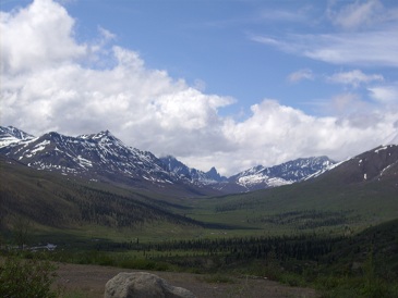
We got a picture of Tombstone Mountain on our way back, as it was clearer then. It is the sharp little peak way at the back in the middle of the picture.
No comments:
Post a Comment