Friday 23 November 2012

Nov 23, 2012


We thought we should finally update our blog.

Our travels for the year ended in late July, when we returned to Calgary due to a relatively minor health issue. 

Once, the health issue was resolved, we checked on medical insurance for travel to the USA.  The limitations convinced us not to head south this winter.  After checking with some friends, we found two house-sitting opportunities for this winter. 

We are in Edmonton until the end of January, and move to Calgary until mid-April.  Then we will take the trailer out of its winter storage, continue our travels, and resume posting the blog.

Shovelling snow for the first time since 2003 is a bit of a deviation from our plan of only seeing snow on mountain peaks.

IMG_0098[1]

Thursday 26 July 2012

Week ending Jul 26, 2012


Obviously we got into McBride on Friday morning to post our blog for last week. We picked up some mosquito repellant stuff (a couple of cans of good muskoil type and two sets of coils). Some folks from McBride who were camping at the rec area told us that they burnt coils just inside the door, with the door and windows opened to the screen for ventilation. This would keep mosquitoes from coming in the door every time it was opened. We found out later that worked okay, but weren't really comfortable with the vapors in the trailer. We picked up some chips and cheese sauce and a few gallons of water. Then we went to the Beanery 2 to have lunch and post last weeks blog. The meal there was quite good, and the charge for the internet was only 1.50. After lunch, we drove back to the rec area. We stopped at the Goat River rest area to take a few pictures, and we stopped just short of our rec area, to walk down to one of the small lakes near us. When we got back to the trailer, we had a bit of a challenge finding a satellite signal, but were finally able to get one by placing the satellite dish right down at the edge of the lake, on a bit of peaty area that settled a bit every time I stepped too close to the tripod legs. A bit of effort for a few hours of TV a day (only when we have the generator running), but remember, this is home, not a camping vacation.

On Saturday, we took it easy around the campsite. We walked up the hill to the highway, to see how long it would take Joan to walk up (8 minutes) to stop any traffic coming down the hill, since the access road isn't big enough to share with another vehicle. We talked for a while to our neighbours, a couple with a one year old from Prince George who were out for one day. He told us that a friend had lost traction going up the access hill, pulling a tent trailer. That made me (John) a bit concerned. After we described what were doing in our retirement, he told us about SPOT Satellite GPS Messenge Service, (http://www.findmespot.ca/en/index.php) a facility that would let us notify people where we were located, even without cell service, or call for help in an emergency, particularly in a location like the rec area, where there is no cell service. We told him that we weren't usually far enough from a highway, or at least a reasonably well traveled road, for it to be an issue.
In the afternoon, John went for a bit of a dip in the lake, with a floater. He paddled back to the edge of the lake behind the trailer, but, as Joan had warned, the bottom was quite muddy there, so we had to rinse off his swimsuit before hanging it up to dry.


Then we set up the tarp that we had bought in Stewart so that the generator was sheltered. It was a bit of a makeshift deal with a concrete block on one corner on the picnic table, the middle over the generator tied to a tree at the edge of the site, the second corner tied to the ground with a tie-down and a 6 inch screw that is usually used for the satellite dish. The other two corners were tied to the ladder at the back of the RV, and the other to the door railing of the RV. This kept the generator nice and dry during the bit of rain in the evening.

It rained a bit overnight, but by the time we started packing up on Sunday morning, the weather had improved. We were happy that our first 3 day 'back country' camping stretch without any services had gone fairly smoothly until we had a problem running the living room slider in. It would start a bit, but not go too far. After trying the manual crank method, and running into the same problem, I decided to see if there was something between the slider and the floor that was causing it to stop. I couldn't see anything, but there was a bit of gravel that came out as I ran my hand along. We dug out the broom and brushed as much out as possible. Then I leaned on the slider as Joan run it in, and, voila, it worked. Phew! 

Then Joan walked up the hill to stop any traffic from coming down. After the appropriate time, I put the truck in 4-wheel drive, for the second time on the trip, and easily hauled the trailer up the hill. We were planning on heading for Valemount for the night, but decided to go the KOA in Hinton instead. We stopped and took a few pictures at Mount Robson and had a quick lunch. Back when I was young, my father and grandfather had a 'thing' about pictures of Robson. One, (I can't remember which) always got pictures of it with cloud on the top, and the other always had a clear view of the peak. 


After a quick lunch, we headed on through Jasper. We took advantage of the people along the way stopped to look at animals in the Park. We got shots of a couple of elk, 


and where even lucky enough to see quite a herd of mountain sheep, including a baby, at Windy Ridge (Joan has a drawing of mountain sheep at Windy Ridge done by a native lady). 


We then arrived in the luxurious setting of the Hinton/Jasper KOA, splurging with all of the services (except a swimming pool) after our 3 days with no utilities. Shower time!

Before lunch on Monday, we drove out to check out the campgrounds and facilities in William Switzer Provincial Park. Only the A loop in Gregg Lake Campground had sites that looked like it would handle the trailer. These sites were heavily treed, so there would be no possibility of getting a satellite signal. We picked up a few items from Hinton, and headed back to the KOA, in the rain.

Tuesday morning, we got up early, and were able to pack up without getting too wet. We decided to drive to the Bow Rivers Edge campground in Cochrane. The drive got a bit wet in several places. We actually saw a few animals. Just past Hinton, a bear started sauntering across the north section of the 4 lane highway. Once it got into the median, it started hearing traffic getting close (well ahead of us), so it loped in front of the traffic heading east, and made it into the bush on the south side of the highway. We tried, but it is tough to get a picture of a moving bear. Somewhere south of Drayton Valley, we saw a few deer with some nice antlers grazing on the fence line. We didn't get a chance to slow down enough for pictures, due to the traffic behind us.
We had a bit of an experience in Rocky Mountain House. We stopped at one gas station for diesel, and managed to squeeze out about 8 cents worth. The attendant didn't think that any of the other diesel pumps would work, so we drove across the street to another station. This one had a sign saying it was out of regular and plus grade gasoline, but it did have diesel. Then, we carried on to Cochrane, and booked into the campground for a couple of weeks to get a good start on watching the Olympic Games from London. They don't have internet access today, but are expecting new equipment to arrive any day.

The internet equipment arrived on Thursday morning, so we were able to update the blog. 

Friday 20 July 2012

Week ending July 19,2012


We started the trip to Prince George on Friday by stopping at the free power wash in Fort Telkwa to blow a layer of bugs and dirt off the trailer and truck. It is a bit of challenge keeping clean when traveling, because only a few of the RV parks have washes, so it is handy when 
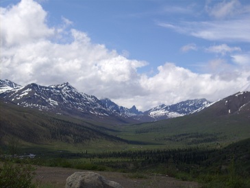
one does. The scenery between Smithers and Prince George gradually changed from snow-capped mountains to rolling hills. Despite cautions to watch for moose on many stretches of the road, we didn't see any. We decided to try out Beaumont Provincial Park on Fraser Lake. However, the roadway was too narrow to even try to back our trailer into a site. Fine for shorter trailers, but not for larger ones.
We pulled into the Kal Tire in Vanderhoef, because the tire that we had filled at Iskut was going low again. After finishing up with a logging truck, the technician took the tire off, found the leak, and had it back on in a short time. When he was done, he wished us a good trip. We said that we would be on our way once we had gone to the office to pay up. But, he said, there was no charge for fixing the leak. We were very pleasantly surprised. The last time we had a tire plugged, at least 10 years ago, it hadn't cost much, but there was a charge.

Once in Prince George, we turned south on 97 about 16 km to the Bee Lazee RV Park. We were able to get everything setup, including satellite, with one of the strongest signals we have found, and the steps. Summer is definitely here, with 30 degree weather, and bunches of young children around taking advantage of the swimming pool here.

We did some shopping in Prince George on Saturday. We stopped at Happy Trails RV to pick up a crank for the rear stabilizer jacks and some florescent bulbs. We went to Coles and found one of the BC Backroad Mapbooks, which we paid with a gift certificate Karen gave us for Christmas. Joan got a haircut. We picked up a new portable CD player (so we have music and radio when we don't have power), since the old one died when something fell on its cassette controls. And, finally, we bought a simple replacement camera.

Sunday morning, we went to John's Aunt Trudy's. She has a very nice condo in downtown Prince George, within walking distance of most things she needs. We tried to connect our laptops to the internet there so she could have a Skype conversation with Dad, but didn't have any luck. She treated us to a very nice lunch at Mr. Mike. Then we drove back to the trailer so she could see our accommodations. We were able to Skype with Dad from the trailer, and she was quite impressed with how it worked. She decided that she should have Skype setup on her machine, so we stopped at Walmart to pick up a webcam, went back to her place. After getting it setup, we Skyped with Dad again to make sure everything was working. We had a very enjoyable day with her.


When we returned to the campground, we went for a short dip in the swimming pool. This was the first day since we have been here that the pool has not been full of young children.

We had a campground day on Monday. We did some cleaning in the morning, and then went for a dip in the pool after lunch. Basically just taking it easy.

We took a trip to check out a couple of recreation areas on Tuesday. We drove a short distance back toward Smithers, then drove south down Blackwater Road. Our destination was Punchaw Lake Recreation Center. The first 24 km of the road was paved, although the first few km had a multitude of small pot holes. Once we got past a treatment center, the road changed to gravel. It was oiled or watered, at least, for the next 24 km. We encountered a small black bear on the road ahead. It took one look at us, and dashed into the bush. The road into the rec site was a bit rutted, and fairly narrow, so we didn't feel we would like to take the trailer down it. The truck had a thin layer of mud on its bottom half by the time we arrived. 


The lake was fairly shallow, with a bunch of lily pads floating near the boat launch. We ate lunch at one of the tables, and enjoyed basking in the sun for a while. We heard this hum or buzz near the truck, and noticed a hummingbird hovering around the truck. We tried to get a picture of it, but it did not sit long enough for us to get one. On the way back, we stopped at a smaller rec site at McKenzie Lake (this area was traveled by Alexander McKenzie during his explorations). The road into this site was very bumpy, and we could see why this rec site was labelled as a tenting only site (no Rvs) in the Backroads book. 

Carrying on, we stopped at West Lake Provincial Park. It is a popular park with a nice grassy area above a narrow fine gravel beach. There is a very wide and deep swimming area. We floated on our tubes for a while before heading back to town. We stopped at the first car wash we could find, to remove the layer of mud from the truck, and to wash out the wheel wells a bit before taking the truck to Kal Tire to swap the front and back tires. Again, we were pleasantly surprised that they did not charge us for this, which included a quick inspection.

We were planning on a trip to Fort George Canyon Provincial Park on Wednesday, which our map showed as being just a few km south down highway 97. However, when we did some research on the web, we found that to the only access was on the west side of the river, which would have meant driving back into Prince George, and back down the road to West Lake PP (where we were yesterday), and then hiking 5 km to the park and another 5 km back. Instead, we did some laundry and then checked out a rec area just east of us at Buckhorn Lake. Although only a short distance away, the road had a lot of washboard, and the campsite would have been awkward to get the trailer into. Additionally, there was a lot of broken glass and nails from boards people had burned in the fires. While we were there, a retired fellow drove in. He chatted with us for a few minutes about what type of RV would work best for him. Then, we drove into Prince George to pick up a few more groceries.

Thursday morning, while packing up the trailer, we noticed that the problem tire on the trailer was low again. We stopped at Kal Tire again, where they found that the tire was leaking all the way around, so was not repairable. They quickly replaced it with a new tire of the same type, which actually cost us less in BC than the previous one had cost in Ottawa. We headed east on Highway 16, and stopped about 30 km out to torque the truck tires, only to find out that the socket that works for the trailer is too small for the truck. So we headed back to Kal Tire again, to get the truck tires torqued, and while we were at it, since we had already put on about 60 km, the trailer tire as well. So back we headed onto the highway. About 150 km, just short of planned stop, the Little Lasalle Lake Recreation Area, we passed about 15 bicyclers heading east. When we got to the turnoff to the rec area, we noticed a sign, that the Jasper bicycle group was stopping here for the night. We parked the trailer along the edge of the highway, and walked the half km down to the campground. We checked with the people doing the bike tour to see how many sites they were taking, and then checked out the rest of the (many) sites. We found a couple that would work for us, while beating off hordes of mosquitoes. Of course the repellant was at the top of the hill in the truck. We walked back up the hill, sprayed some repellant on, and took the trailer down the hill.  We were able to manouver the trailer into one side of a double site, with the back window looking out over the little lake. This will be our first night so far in an unserviced free rec area. We spent a quiet evening, swatting the occasional mosquito that snuck in while we were getting in the trailer. 


No internet of course, so we can't post the blog on Thursday night, but we drove into McBride on Friday to pick up some more water, mosquito repellant (we were lulled into forgetting about it in the Prince George area), check e-mail, phone, etc.


Thursday 12 July 2012

Week ending July 12, 2012


Friday was a bit of a lazy day. We tried to adapt our satellite connection so we could connect outside instead of through a window. Unfortunately, the connector was the wrong size. The internal connections are smaller than the cables running to the outside connection. After lunch, we did a quick test on our generator, figuring it would be better to do that where we have an alternate power source than waiting until we were in an unpowered site. Then we went for a short walk through the woods next to the RV park. The views weren't as good as the one from our trailer.

We had a bit of an issue on Saturday morning. While backing off far enough to see if all of the vents were closed on the trailer, we noticed that a brake line on the trailer was disconnected. Flashbacks of last June in Ottawa. The folks at Mountain Shadows RV Park kindly phoned Joe at Bandstra Trucking to see if he was around. We drove the few kilometers to his place just south of Iskut. After about an hour of working on the problem, he had fixed the brake line, found the fluid reservoir, filled it, bled the lines, and made sure that the brakes were operational again. He also topped up the air in one of the tires that was a bit low. We were back on the road again by 10:30, happy to have brakes on both the truck and trailer again, all for a very reasonable price.

The section of the Cassiar Highway between Iskut and Meziadin Lake Provincial Park showed hints of beautiful mountains, peaking through the clouds that hung over the valley. We encountered a nice little black bear that was walking along the ditch right next to the road, heading south like us. We got a quick picture from the driver's side, then drove forward a bit further, as the bear just kept walking along. Before we got another shot, he crossed the road behind the trailer, and started walking towards us on the other side. We got a few more decent pictures. We also saw another bear, further along, but it wasn't posing for us. 


Once we arrived at Meziadin Lake Provincial Park, we chose a site on the lakeshore. After about 20 minutes of frustration, bickering, and flaying away at the mosquitoes while trying to back the trailer into the site, we gave up, and backed into a site above the lake with much more elbow room for the truck, and still decent views of the lake. We have lost our touch, having too many pull-thrus. No power here, so this was our first live experience with the generator. Hours allowed are 7 to 10 AM and 5 to 8 PM. At 5 sharp, we went through the process of adding some gas, and starting the generator, after spending some time deciding where we could run it out of the drizzle, with adequate ventilation. We got it going with no problems, plugged in, and it almost immediately went off, due to an overload. We decided to switch from the electric heater to the propane furnace, since we are paying for the fuel one way or the other, and the furnace is probably more efficient anyway. We also switched the fridge to propane, then started cooking burgers in the electric frying pan, and everything was going fine, TV's on, computer plugged in. Then we turned on the hot water heater. Overload again. Switched that off, restarted the generator, and started cooking supper again. 10 minutes later, the generator stopped. Out of gas this time. Put in more gas than the last time. Hopefully that will get us through to 8 PM. We finished cooking and eating supper, and watched the last two thirds of the NASCAR race. Meanwhile, we smacked the occasional mosquito as it came near us. Mosquito season has definitely arrived.

We drove to Stewart along Bear River on Sunday morning. The views of the mountains, glaciers and waterfalls along this route are fantastic.

Once in Stewart, we walked along the estuary boardwalk, out towards Portland Canal, which connects to the Pacific Ocean.


We stopped at a recreation area on the way back, just past the temporary bridge that was put in place while they fix the washout that happened this spring. The rec area was a little lake where a couple were teaching their grandchildren to fish. They told us that someone had seen a large bear in the area.

It was drizzling on Monday morning when we packed up to head south, so we didn't even bother turning on the generator, had a breakfast of biscuits Joan made the day before, and were on the road by about 7:30. We saw fairly large black bear that was crossing the highway well ahead of us. We took too long trying to zoom in, and it dashed into the bush and disappeared. We stopped at the Gitwangak Battle Hill National Historic site, just north of highway 16. We walked down 108 steps to the valley floor, and then back up about half that to the top of little hill where a warrior chief had located 5 lodges which were defended by rolling large logs down the hill on attacking enemies from the coastal tribes. We were also able to get good views of the Seven Sisters mountain range. 


Just down the road, we stopped at a restaurant at the junction for coffee, which turned into brunch. Then we carried on to Smithers, where we refreshed our cash and grocery supplies. Once done there, we headed to the Fort Telkwa RV Park, 12 km east of Smithers, and set up overlooking the Bulkley River. A nice spot, but a little noisy, between the highway and the CNR line.  However, it didn't keep us awake, and after a while, you don't really notice the traffic.  The weather here is the warmest we have seen for weeks, quite different than the drizzle we left behind this morning. The wi-fi process here is interesting. Included in the price for the day, 75 mb of internet use are included. When you have used that up, your account is stopped for the day. This keeps people from downloading videos, and doing other bandwidth intensive stuff.  We found this worked okay, except for our weekly Skype talk.

Tuesday, we drove to the Twin Falls Recreation Area and had lunch at a picnic table with great views of the falls. 


Then we did Smithers Culture Crawl 2012 walking tour using a brochure we had picked up at a rest stop coming down the Cassiar. It told us about 4 'kit' houses that were bought from Eaton's and an American catalog company. We were surprised to see that these were significantly sized two story houses. We read about Swiss and Dutch emigration to the area, saw a display of information on the Queen's Diamond Jubilee in the town hall, and walked through the gardens at St. James Anglican Church. We checked and sent e-mail at the library. When we got back, we checked our camera, after replacing the batteries, and found that it appears to work okay except the display screen doesn't show anything. We will just have to hope that we have the camera pointed in the right direction, or start using the camera in the phone.

We had a quiet morning on Wednesday, doing laundry, and installing the satellite connector so we don't have to run the cable through the back window of the trailer. In the afternoon, we took our 'floaties' to Tyee Provincial Park, and enjoyed the sun and the water.

We drove to Driftwood Canyon Provincial Park on Thursday, and walked the short interpretive trail describing the First Nations in the area, and the fossil beds, where fossils of ancient plants, insects and fish were discovered. Then we drove out to Chapman Lake, a recreation area about 38 km from the highway through the Babine Range. It is a nice little site, with about 8 campsites on a decent size lake. A lady that had been there for about a week told us that there were leaches in the lake, so that , and the hungry insects, made our stay fairly short.

Thursday 5 July 2012

Week ending July 5, 2012


We went for a few short drives from Atlin on Friday. First we headed south down the lake to Warm Bay, Warm Springs and the Grotto, several beautiful little spots along the way. 


We also took a quick look at the several recreation areas along the way, free primitive campsites. Palmer Lake recreation area was the spot we chose to stop for lunch. It had a trailer occupying one of the two campsites. We spotted a small black bear looking at us from the side of the road. It quickly decided to head into the bush. A short distance down the road, a rabbit went scurrying across headed in the opposite direction.  We walked up McKee Creek, one of the old gold mining creeks in the area.


When we got back to town, we headed east, up Pine Creek, where the gold discovery was made here in 1898. Yes, Atlin is another gold town, and there is still some mining on Pine Creek. We stopped and got some pictures of Pine Falls. 


At the Atlin Airport, there were 20 to 30 small planes parked along both sides of an old runway. Apparently there is a 'fly-in' this weekend, with about 50 to 60 planes expected. We carried on to Surprise Lake, about 18 km from town. It was formed by damming Pine Creek for a small First Nations owned hydro plant that provides power for Atlin. We checked out the 6 campsite recreation area on the edge of Surprise Lake.

Saturday morning we walked around town. The Atlin Claim newspaper, which the campground operator provided to us, has a map of town, with the location of all the highlights, sort of a self-guided tour. We wandered pretty much all of the streets in town. Many of the buildings have little signs explaining their historical significance. Like most of the places along or near the Alaska Highway, there are several businesses for sale, or boarded up. However, there are still several places to eat, and a decent grocery / bakery. We picked up lottery tickets and some tasty date squares at the grocery. In the afternoon, we caught up some sleep, and then watched the NASCAR race and the football game (flipping back and forth).

We drove back up through the construction between Atlin and the Alaska Highway. It was a bit easier, because there was no work going on Sunday. We set up at the Yukon Motel RV Park in Teslin. Spots were a bit limited, as a caravan of RV's had booked most of the sites.We watched them all come in late afternoon, and then leave in a group on Monday morning. We were only able to get a 20 amp site, so we had to watch which appliances we ran together. We had to reset the breaker a few times.

After they left, we did a walk around Teslin, following a route in a brochure, marking the various buildings of significance. Around town, particularly near the George Johnston Museum, there were lots of interpretive signs giving the history of the area, from the Tlingit Nation, to the river boats that started from here to Whitehorse during the gold rush, and then to the Alaska Highway building. Unlike most of the towns on the highway, most of Teslin is hidden from view, so you don't realize most of it is there if you stay on the highway. Once again, another caravan arrived in the afternoon. We were hoping to get on the wi-fi, which is only available in the restaurant area, but the connections we got would not give us access to the internet. 

We woke up early on Tuesday morning, and beat the caravan out, not that we had planned to. We drove to Junction 37, almost, and stopped at the Baby Nugget RV Park. We passed the area of the road that had washed out just after we came through heading north. Before parking, we washed most of the gravel and dust off the trailer and truck. After relaxing for the afternoon, we enjoyed a dinner of fish and chips and a bison burger smothered in onions and gravy at the 'Wolf it Down' restaurant next door.

We moved on Wednesday morning, driving down the Cassiar Highway (37) from the Alaska Highway to Dease Lake BC. The first section of the highway was fairly narrow, and a bit rough. The next section wasn't too bad. The last stretch along Dease Lake had a fair number of broken sections. We saw some more wildlife along the way, but weren't able to get any good pictures. The first animal was a black bear. We may not have noticed it, but some folks heading north had stopped to watch it. The next animal was a fox. We saw it from a fair distance, so were able to stop and get a good look at it. It had caught a bird, which it was carrying down the highway. Along one of the marshy areas, Joan saw a moose, but we weren't able to find a spot to stop and walk back for some pictures. In another spot, we got a glimpse of another bear grazing in the ditch. The scenery along the route was varied. The northern section was like a roller coaster, but you couldn't see much through the trees. In this section, in northern BC,  there was a long stretch that had been burned not too long ago.  Here, we started to see bunches of tents in the bush along the way.  The mystery was solved when we went by some vehicles and tents next to the road with the sign 'Mushroom Buyer' out front.  There must have been at least 50 tents over a long stretch, with a couple of other buyers.   A new form of 'gold rush' in the north! 

Once we got through this section, which is part of the Yukon plateau, we entered the Cassiar Mountains. The road winds through the valleys with distinct peaks on all sides. In this area, we came to Jade City. 92% of the world's jade is extracted from 3 mines in the area. Most of it is sold to China, as it has exhausted its local supply of jade. We took a quick look through the store, but couldn't justify the prices for even the smallest pieces. If jade is your thing, they do have a lot of very nice items. The final stretch of the road wandered along the edge of Dease Lake with many views of the lake.

We moved on about 80 km. to the Mountain Shadows RV Park on Thursday morning, arriving just after 11:00. We have a nice spot here, looking down toward the end of lake that stretches a few km south. Off the end of the lake, a bald eagle was perched high in a pine tree, watching for some lunch. After lunch, we walked down to the lake. There were a few rainbow trout feeding on the bits flowing into the lake. After we checked out the boat dock, and watched a fellow raking weeds out of the shallow end of the lake, we walked along a path above the lake to a deeper point on the lake. We relaxed in the sun for a while, and watched a small shore bird hopping along looking for food.


Thursday 28 June 2012

Week ending June 28, 2012


We headed north-west from Haines Junction on Friday mid-morning, along the edge of Kluane Park. We stopped close to the south end of Kluane Lake, the Yukon's largest lake, for a short hike along the old Alaska Highway, which went over a shoulder of the hill, to Soldier's Summit. This was the location where the official ceremony was held to open the Alaska Highway. We chatted with a couple from Seattle, who had come up the Inside Passage on the ferry from Prince Rupert. We drove the rest of the way along the lake to Burwash Landing, one of the oldest settlements in the Yukon. We toured the very nice Kluane Museum of Natural History. They have excellent displays of the native animals and birds, and of the clothing and tools used by the native people. On the way back, near Congdon Creek campground, a grizzly was coming along the highway toward us. Before we got near it, it went off the edge of the road down toward the creek. We were able to turn around at the campground and come back to get some pictures of the bear as it went down along the creek. 

Carrying on, at the south end of Kluane Lake, we noticed a vehicle down by the shore with a woman waving frantically at us. We pulled onto the turn-off by the lake and saw that they had gone down into the sandy area by the shore in their SUV and had their rear tires deep in the sand. They had a tow rope, but it only reached about halfway to an area of solid gravel. Shortly after, a Yukon government employee stopped to help. He had another tow rope, so we were able to back close enough to the suv to attach, and have the front tires on the solid gravel slope. After digging out the back tires of the suv, and some pushing, we were able to use the 4-wheel drive (for the first time) to pull them up to solid ground. When we got back to Haines Junction, we stopped at the bakery where we had a nice bison cheese dog and bumbleberry scone, and picked up a loaf of bread.

We had been watching the weather forecast for a good day to do an airplane flight over Kluane, and Saturday was predicted to be clear. We took the Grand Mountain Tour, a 75 minute flight in a Sifton Air 5 passenger Cessna 206. This tour flies up the Kaskawulsh Glacier which flows off the Hubbard Glacier, one of 4 main glaciers starting from the icefields around Mount Logan, Canada's tallest mountain. 

The Hubbard Glacier goes 76 km down to the coast in Alaska. Since it such a clear day, we got beautiful views of Mount Logan. 

We got some pictures of the beautiful sapphire (?) colored glacial pools. 

On the loop back towards the airport, we came down to Lowell Lake, filled with little icebergs that calve off the Lowell Glacier. These icebergs float around in the lake all summer, as the drainage is too shallow for them to move into the Alsek River. 


Sunday was a very quiet day. We drained the trailer and refilled the water tank. Then we watched the NASCAR race.

We moved to Whitehorse on Monday, back to Pioneer RV Park where we stayed before.

We went to visit a friend here on Tuesday. Jackie is visiting her daughter and family on their acreage at the edge of Whitehorse. We spent a very nice afternoon with them. On our way back to the RV Park, we checked a few places looking for a spring to replace one that broke in the recliner chair. We found one at Home Hardware that was an exact match. Now we just need to figure out where to install it in the recliner.

Wednesday morning was laundry time. After laundry, we installed the spring in the recliner. We had looked at it before to see if we could figure out where to install it, without any luck. Today, we were able to find a picture of a similar recliner mechanism that showed roughly where the springs needed to be connected.

After lunch, we went to the Berengia Interpretive Center on the highway beside Whitehorse. This was well worth the $10 (for two seniors). Berengia was a dry area with extensive grasslands that covered both sides of the Bering Strait, from Siberia across Alaska and the Yukon. It was created during the ice ages, because the seas dropped about 100 meters due to the amount of water that was trapped in the glaciers. The center has some excellent skeletal reconstructions of mammoths, short-faced bears, sloths, scimitar cats, giant beavers (the size of a black bear) and other large animals that lived in this area during the ice age. There were also displays of human habitation from this era. They had several short films that provided explanations of the phenomenon. 

After we were done there, we went to the local Honda dealer to buy an inverter/generator for the trailer. This will give us more flexibility in campgrounds, as we won't be as dependent on having a powered site.


We packed up again on Thursday morning, and headed down the road to Atlin, BC. Although not a long drive, it was a little more challenging than most. About 60 km of this road is gravel, including a rough section of about 10 km that was under construction. By the time we got to Atlin the lower parts of the truck and trailer were covered in a slimy coating of mud. The campground here is a little more primitive than most, with only 6 water and power sites (no sewer). However, we were fortunate to get the 'Penthouse' spot, which is on a strip of gravel built between the marina and the houseboat moorings. The houseboats used to be short term rentals, but now appear to have full-time tenants. We also have wi-fi, and were able to get the satellite working.
The views are fantastic, with mountains rising along the west side of the lake. As we were relaxing in the trailer in late afternoon, a bald eagle landed on a platform behind the trailer, and proceeded to eat the animal or fish that it had caught.

Thursday 21 June 2012

Week ending June 21, 2012


On Saturday morning, we drove up to Midnight Dome, a hill behind Dawson City. From the top, there are extensive views in all directions.  Here is a view of the Yukon valley as it heads toward Alaska. 


On the way down, we got some pictures of a fox on the road. 

We checked out the farmers' market, but it is too early to have any produce.  As we were walking along the dike that protects Dawson from the Yukon flooding, we saw the SS Keno on the river practicing abandoning the boat if it lost power and was swept downstream, very quickly.  They would run the boat upriver for a while, then cut the engines, letting the boat drift, then restart the paddle-wheels and head upstream again.


We drove the 96 km Hunker Creek / Bonanza Creek mining loop. This is a mainly a gravel loop, mostly not too bad in the lower valleys, but the road climbs up on a ridge between the two creek beds, along King Solomon's Dome, which is believed to be the location of the mother lode that fed gold down the creeks in all directions. This part of the road is not so much gravel as packed sand, so has a lot more potholes and ruts. The views from the top of the ridge were fantastic, with a 360 degree view for huge distances.  These views never look as impressive in a picture as they do in person. We stopped at the two main National Park Historic sites on Bonanza Creek, the Discovery Claim, and Dredge #4 to learn more about the gold rush. 

When we got back to the RV park, we filled up the truck, getting the 4 cent/liter discount for campers, but weren't able to get the discount on the fill we did when we first arrived (before we knew they offered the discount). Then I took the truck over to the car wash, to remove the calcium chloride mud that comes of the gravel in this area (where they have treated the roads to keep down the dust). The wash wouldn't start after the money was put in. It turned out that the compressor had been unplugged. By the time that was sorted out, I only had a couple of minutes left on the timer (apparently it wasn't unplugged). It took a while for the clerk to find the manager to give me some more time.

We drove back from Dawson City on Tuesday. We saw a fox crossing the highway not too long after we started, but it was moving too quickly to get a picture. The trip back to Carmacks was fairly uneventful, as we are just retracing our path here.

Wednesday morning, we were off early as we didn't unhook the truck. We drove back to Whitehorse, mostly in rain, picked up some groceries and a cigarette lighter USB adapter for the phone. Since we had no cell service since we left Whitehorse for Dawson City, we hadn't recharged it. Even leaving it at customer service in Superstore while we shopped didn't get it charged enough to use. Shortly after leaving the coverage area in Whitehorse, on our way to Kluane Park, the phone was charged enough to find out that we were out of range. The 'Fas Gas' RV Park in Haines Junction has 30 amp power, but no water or sewer. We emptied our tanks, filled up our fresh water tank and paid for one night, to be sure we could get wi-fi and satellite before we committed to longer. As I was setting up the satellite, the next door neighbour (i.e. The only other trailer in the park at the time) came out, and I asked him if he had a satellite signal. We checked his settings, and I found my dish angle need to be raised, and we wound up with a better signal than the neighbour. We chatted for a while with him about our stay in Victoria, as he is thinking of heading there for the winter. Then we paid for 4 more nights, since everything was working fine.

When we went to the Parks info center on Thursday morning, we found out that there was a blessing ceremony to officially open the new DÄ KŲ Cultural Center of the Champagne and Aishihik First Nations . It also is the new home of the Kluane National Park visitor center and the Yukon Government visitor center. After enjoying the ceremony, we drove south down highway 3, and walked the Rock Glacier trail, a 1.6 km trail climbing out of the valley to the rock scree at the foot of an old glacier. There were great views of Dezadeash Lake in the valley. 

Then we stopped at Kathleen Lake on the way back. We learned that Kokanee salmon are Sockeye salmon that no longer go downstream to the ocean, but stop in a freshwater lake before going back upstream to spawn. We a short walk along the edge of the lake very quickly, because the mosquitos were quite bad, and the repellent we used on the previous walk had worn off. 

As we continued back to the campground, we encountered a mother moose with a calf on the edge of the highway. They stood on the edge of the road with the calf tucked under mother, looking out at us from the far side of her. By the time we got the camera ready, and tried to zoom in a bit, they had turned and headed down the highway. The walked along the edge a bit, but as we slowly moved toward them, the made a bee-line into the bush, and had disappeared by the time we got to the point where they headed off.

Saturday 16 June 2012

Week ending June 15, 2012


We took Friday morning to do catch up on laundry, and to wash the gravel off the back of the trailer from the several gravel stretches on the road from Watson Lake. After lunch we drove the few km into Whitehorse to get some groceries and do the tour of the SS Klondike, the paddle-wheeler that used to carry supplies down the Yukon River to Dawson City, and then bring the silver ore back up the river to Whitehorse from the Keno area east of Mayo.


We were going to go to Haines Junction, next to Kluane National Park on Saturday, but the weather forecast looked better on Sunday, so instead we decided to do some things around Whitehorse. In mid-morning, once it had warmed up a bit, we went over to Miles Canyon, which is on the Yukon River close to the RV park. It is a nice little narrow basalt canyon with walking trails on both sides. We did about 1 km downstream to Shwatka Lake, and back, and then had lunch on a rock looking over the canyon.


After lunch we went into town to the visitor center, where we found out they didn't have a self-guided walking tour of Whitehorse, because the heritage museums in town have a monopoly on that. We also found out, overhearing a conversation with the people in front of us, that the road between Watson Lake and Teslin Lake had washed out for about 200 meters on Thursday, sometime after we had driven that route. They figure it will take at least a week before the road is passable again. In the meantime, they will have to start flying groceries into town. We walked down main street, and looked in a few of the shops there. Then we stopped for a drink at Tim's, picked up some nuts and washers to tighten up the rubber bumpers on the trailer hitch, and bought some ice cream. Then back to the RV park to put the nuts on the hitch bumpers, and enjoy the sun.

The weather was good on Sunday, as predicted, so we headed to Haines Junction to check out Kluane Park. The valley going from Whitehorse was fairly level, with foothills on both sides. After a couple of hours of driving, with a few stretches of gravel surface similar to the road from Watson Lake, we stopped at the park visitor center to pick up some information on hiking in the park. Most of the hikes are several hours, and / or an hour or two further down the highway, but we did a 4 km walk next to town along a small river. The mountain range is quite spectacular, as it rises in a wall. 


We watched an interesting movie which was just made about the park, showing some of the scenery from the interior of the park, the wildlife of the park and the relationship which the local natives have with the land. We checked out one of the RV parks, and may return with the trailer on our way back from Dawson City to do some longer hikes. 

Monday morning, we managed to get the cell phone tethering to work, with some difficulty and paid some bills and checked our accounts. Then we headed toward Dawson City. The hills along this route are quite scenic, and there are several lakes close to the highway. We stopped at a viewpoint, which had a short interpretive trail describing an extensive forest fire in 1998. Then we had to pick up a world famous cinnamon bun from Braeburn Lodge. This  bun was huge. The Milepost guide said each one was enough for 4 people, but that didn't mean 4 seniors. However, we still think the Tetsa River cinnamon buns had the best flavour. We decided to stop at Carmacks for the night, since it would be fairly late if we went all the way to Dawson City and stopped to see anything along the way. The little RV Park behind the Hotel Carmacks was fine for a one-night stop. However, our site didn't have a line for satellite, and the wi-fi was provided through a 3rd party, so we did without both for one night.

On getting started Tuesday morning, we found out that our little campground only had laundromat and showers, no washrooms, and even these were not open until 8:00 AM (we checked at 7:55). After driving down the road for a while, we stopped at the Five Finger Rapids viewpoint. We couldn't get to the interpretive signs, because the platform they are on is closed. However, we were able to take the short walk down to the river, starting with 212 (or 219, according to Milepost) step stairway. 


We stopped for snacks at Pellee River Crossing, and switched drivers. Joan decided we needed to keep track of who drove which sections, as the road is a bit narrow with rough breaks, so the driver can't spend too much time enjoying scenery. We pulled into Dawson City about 3:00 in the afternoon. We had decided to stay at the only RV park near town that didn't have reviews, as the reviews on the other two were not good. We only booked for one night, to make sure that we had decent wi-fi, and could get a satellite signal. The manager put is in a spot that worked fine for both, so we paid for 6 more nights. The next door neighbours weren't pleased, as we had to move their table a few feet toward their trailer to get it off our site. They couldn't understand why we were put right next to them when there were many other vacant sights available.

We went to downtown Dawson City on Wednesay morning to do the walking tour of the historic buildings. On the way into town, on the bridge across the mouth of the Klondike River, we had to stop while a confused deer came up one side of the bridge, looked around a bit, then crossed the bridge, and went into the woods on the far side of the bridge. The historic tour started at the museum, so we looked at the exhibits in the museum. They have done a very good job. After about an hour of going through the first gallery, we continued on the rest of the tour, which included the main government buildings, several churches, and the cabins / houses of the three main authors of the Klondike era, Robert Service, Jack London and, more recently, Pierre Berton. Then we returned to the museum and went through the rest of the exhibits, and wrapped it up with the Chechako presentation in a tent on the lawn of the museum, where a couple of entertainers gave a bit of background on the gold mining days and answered questions from the audience about the era.

On Thursday morning, we went back into Dawson, and spent 3 hours checking out all of the shops and buying some souvenirs and groceries. We heard from one lady that the deer we saw yesterday is fairly rare in this area, and a tour driver that we met at the Diamond Tooth Gerties show was shocked that we had seen a deer. We won a bit of money on the penny slots waiting for the show to start, and enjoyed the singing and dancing. After the show, we got a lot of advice from the tour driver about which drives we should do in the area. 


Friday was our day trip to Tombstone Territorial Park, along the Dempster Highway. It is a very scenic good gravel road up the North Fork of the Klondike River through the Ogilvie Mountains, across the continental divide and down the Blackstone River. In the process you go three 3 ecological zones, starting with the boreal forest in the Klondike valley, proceeding to sub-alpine at the head of the river, and then into Arctic tundra in the Blackstone valley. We saw a black bear around km. 61 of the drive, about 10 km from the interpretive center near the summit. It took a quick look at us before heading into the bush so we couldn't get a picture. The interpretive center has a lot of interesting information about the area, and has been built to have minimal impact on the environment. We took a short walk from the campground along the river to an ice sheet that gets formed every winter. The first layer of ice freezes in the low areas next to the river, and then more water flows onto it, forming many layers of ice. The sheet eventually thaws all the way through by late summer.  


We got a picture of Tombstone Mountain on our way back, as it was clearer then.  It is the sharp little peak way at the back in the middle of the picture. 


Thursday 7 June 2012

Week ending June 7, 2012


We spent Friday morning doing the Dawson Creek historic walking tour. They have done a nice job of putting up plaques on the various highlights in the downtown area. They have also done many beautiful murals depicting Dawson Creek's history. Unfortunately, we didn't take our camera with us, so didn't get any shots, but you can check them out at


We also picked up some nice sweet kopf and a loaf of bread at the Tasty Bakery.

In the evening, we chatted with a couple, Bobby and Marcia, from Texas about what we should see and where the best places were to stay if we go there next winter.

Here is the Alaska Highway Mile0 signpost, the start of our trip to Dawson City.


We started our trip up the Alaska Highway on Saturday morning. While hooking the trailer up, we noticed that the nuts had come off the rubber bumpers on the trailer hitch. We taped them down just to make sure that they didn't come out of place until we can replace the nuts. We stopped in Ft St John for Orange Julius's, then decided to carry on to Fort Nelson. We saw a moose along the edge of the clearing by the highway between Ft. St. John and Pink Mountain, but didn't get a picture this time. We were surprised at how straight some of the stretches of road were, with not too much to see besides the trees. We checked into the Triple G Campground in Ft Nelson.

It rained until the evening on Sunday. We had a quiet day in the campground, watching the Nascar race from Dover. Joan cut John's hair, repairing the bad haircut done when we were in Calgary.

Monday, we drove from Fort Nelson to Liard River Hotsprings. It was still overcast, so we were only able to get glimpses of the mountains as we drove across the northern end of the Rockies. We stopped at the Tetsa River Services, which is 'the cinamon bun center of the galactic cluster'. The buns were quite tasty, and almost big enough to justify the $5 each. We filled up with diesel at Muncho Lake, with the most expensive prices so far at $1.89 We did get some advice thrown in free, as someone had just taken out the cooling lines on their car driving over rock which had fallen on the road from the cliffs next to the lake. Fortunately, we didn't run into any rocks on the road. After km's and km's of wildlife warning signs, we finally saw a Stone sheep at the base of a rocky face. It was kind enough to stay posed for us as we walked back from the first turnout we could get to. 


Closer to Liard River, we saw 2 separate wood buffalo grazing along the edge of the road. They paid absolutely no attention to us, and the group ahead, as we stopped to take a picture. 


Once we got parked in the Provincial Park campground at Liard Hotsprings, we enjoyed a nice soak in the hotsprings, chatting with other travelers. 


These are natural pools with a gravel bed. 

Our night here was our first night without any services since we bought the 5th wheel in May last year.  I was a little concerned about whether the furnace running frequently during the night would leave the batteries with enough juice to run in the slide-outs and raise the goose neck up to hitch it to the truck. The latest slide-out was a little slow coming in, but we didn't have any problem. Once we hooked up, we walked to the 'hanging gardens' by the hot pools. 


The trip from Liard to Watson Lake was fantastic. We saw more animals along the roadside on Tuesday, than we have seen for the whole trip. There were several bears, a few groups of wood bison including one that had a couple of bears close by, and even a moose couple that we just caught a glimpse of as we passed a small body of water. We weren't able to get pictures of all them, particularly the moose, but we did get some good poses. 


We stopped at the Coal River Lodge, only about an hour out for an early lunch, as they advertised good bison burgers. Despite having only a few tables, the food was worth the stop. They also had a selection of t-shirts, stuffed animals and signs that we perused while waiting for our lunch to be prepared. We stopped at a viewpoint above the Liard River valley, to get some photos to show the nature of the valley. After arriving in Watson Lake and getting set up at the Downtown RV Park, we walked over to the famous Sign Post Forest, checked-in at the visitor centre to get excellent information on the Yukon highlights, and then wandered back to our RV to settle in for the evening. 


Wednesday morning, we decided to stay for another day, since yesterday was so eventful, and take it easy. While Joan was paying for another night, she noticed a sign, and got some free rhubarb, and cooked it into a sauce for our morning cereal. After lunch, we walked the interpretive trail around Wye Lake. It was a nice little 2.5 km walk with several interpretive signs explaining many of the plants in the area, and had a section about each one explaining how the natives used them for food and medicinal purposes. We even had an explanation about how Cypress Hills on the border of Alberta and Saskatchewan in the south was named for it's lodgepole pines, because the early explorers thought they were jack pines, which are called 'cypres' in French.

We drove from Watson Lake Thursday morning toward Teslin Lake. Although it was drizzling most of the way, we were able to do a 10 minute walk to Rancheria Falls during a dry spell.  

We stopped at a lookout over Teslin Lake for lunch, then fueled up at a decent price, with a 4 cent per litre discount. It was overcast and rainy, so we weren't able to see much of the hills along the way, so we decided to carry on toward Whitehorse. Despite the lack of sun, there were no animals visible today. We stopped at Johnson's Crossing for their world famous cinnamon buns. Although good, the ones we had at Tetsa River Services were richer, so worth the extra $2 they charged. We stopped at Pioneer RV Campground, which is about 10 km from downtown Whitehorse. We have good wi-fi, and finally have service on our cell phone. The cable TV has a wide selection of channels, so gave up after a quick check for the satellite signal in the rain.