Thursday 27 February 2020

Week ending Feb 27, 2020 Quartzsite LTVA


Friday was a quiet day, watching curling.

Saturday early morning we started getting a bit of rain.  Then mid-morning we go a lot more.  The little washes between the rows of trailers started flowing.
water in the shallow wash beside the trailer
Instead of turning on the TV we listened to Quartzsite KBUX radio.  It is tailored for us baby-boomers with 50's and 60's music.  Unfortunately, you can only get it within about 20 miles of Quartzsite.   By noon, the clouds had cleared off quite a bit. 

Sunday we walked out to the stone cabin we had seen from Chocolate Mountain.  We parked near a camp spot we had picked out to move to in about a week, but found someone had occupied it.   There were a few spots still holding the rain from yesterday.
 
creosote bush flowering
stone cabin
deer tracks
maple leaf quartz

Monday, we did a walk east and south for just under 6 miles.  A few flowers, perhaps as a result of the rain.   One bush, a Baja Fairy Duster was very prolific. 
Baja fairy duster
flower next to quartz
little yellow flowers

 And a few birds.

woodpecker
cactus wren

cacti boxing ;)
We followed a pink ribbon trail with a faint ATV track back west to the trailers. 
pink ribbon

Back in the LTVA we saw an interesting custom-made trailer.

semi-trailer conversion
In the afternoon we tested our sewer tote, walking the first load the 1/4 mile to the dump station.  Since that worked well, we took a second load hitched to the truck.  Joan walked behind for about half the way to make sure our cotter pinned wheel didn't come loose.  It worked fine.

Tuesday we retraced our route from soon after we arrived here, going NE to the road running southwest from the north LTVA.  Then, we followed it NW toward the north LTVA entrance, arriving just short of the garbage bins in that area.  We saw an RV with a hitch platform at the back, folded up.  We chatted with the lady who owns it.  She had ordered it from Amazon, and found it useful for carrying stuff.  It even held a teak chest that took 3 people to load it, so it can hold a good sized load.  We were thinking of getting one to hold the sewer tote, putting it in the truck hitch.  Joan did some measurement with her walking pole.  When we got back to the trailer Joan found that the top of the platform would be a few inches above the low point on the flow through tailgate.  There are likely ones a little smaller than this that would still be large enough for the tote, but fold up below the low point on the tailgate. 

Wednesday morning just as the heat was getting up to a nice temperature during breakfast, the propane for the heater ran out.  Good timing, as we planned to go into Yuma today to fill two of our three tanks, get another two weeks of u-pick grapefruit, and some groceries.  We chose Yuma rather than Blythe and Parker, which are less than half the distance because the propane and grapefruit are the cheapest around.  Probably not quite worth the extra distance, but close enough for us.   The trip took a little extra time, about 12 minutes, because there was a section of the highway with one side closed for crack tarring. 

Thursday, we drove a few miles south to the road that heads west to La Paz Valley, an unincorporated hamlet about half a square mile about 5 miles south of Quartzite.  We parked in the Roadrunner 14-day BLM camping area next to highway 95, and walked the 1.5 miles west to the area.  Along the way we noticed a BLM marker with an unusual icon on it.  It turned out to be for the Arizona Peace Trail, a new trail which crosses here on Old Yuma Road,  the western boundary of the LTVA north of here.
AZ Peace Trail sign
In the hamlet, there are two large RV parks there, and a fair number of residences.  At the end of the roads, there are signs indicating who lives down each road. 

list of residents down the road
more residents
 
At the west edge of town, our topo map points of interest lead us to the Eightmile Well.  We couldn't figure out 8 miles from where. 
Eightmile Well


Hard to imagine  there were cattle ranging here.
cattle loading chute 
After we got back to the truck, we drove west to Old Yuma Road, and followed it back to the LTVA rather than driving back up the highway.

Thursday 20 February 2020

Week ending Feb 20, 2020 Quartzsite LTVA

Friday morning we packed up the trailer and dumped the sewer before heading to Quartzsite La Posa LTVA. 

Saturday we went for a 4 mile loop heading east, then south, and then returning to the trailer.
More saguaro here than at Yuma
Stone pattern

Sunday morning we walked across the highway to the LTVA section on the west side, closer to the hills. 
hills to the west
We found a nice little spot over there that we might move to in a couple of weeks.

Monday morning we went into Quartzsite to do laundry at the Main Street Laundromat.  It is conveniently connected to the Main Street Eatery.  After starting our laundry we had breakfast.  Reasonably sized portions.  The server (manager?) warned us that coffee might be limited as the water was out.   Never twigged with us, but when we checked our laundry, it had stopped.  It started filling, but didn't finish.  Fortunately the water came on shortly, and the manager put money in the machines so that we didn't have to pay twice to get our loads done.  Chatted with a few other people doing their laundry on the same row (lots of machines). 

Tuesday we went for a longish walk to Chocolate Mountain Gold Mine and Stamp Mill.  The route from the trailer across the highway into the LTVA on the west then north on the west side of the LTVA until we cut across Tyson Wash, a wide wash running south from Quartzite,  to the mine was 2.80 miles. 

There were two sets of structures on adjacent hills, two little volcanic cones.  The one on the north is known as Q Mountain, as it has a Q made of white stones on the northeast side facing town. 
Q
Quartzite from the mine
There is a trail to the top of Q on the south side, but we passed on it today as it is already a long trip.
hike to top of Q Mountain
After checking out the north structure, we headed across the hill to Chocolate Mountain, walking up the road to the structures there.
tiny flowers
These ones are more elaborate and in much better condition.

Chocolate Mountain Gold Mine
LTVA from Chocolate Mountain


what is NO BO? read the fine print


On the way back, we cross-countried.  Consequently, we flushed a hare, the first one we have seen in quite a while.

Wednesday we headed northeast toward a road running southeast from the LTVA area north of us. It is about 1.5 miles away, with no ATV trails headed in that direction.  We crossed a couple of wide areas that looked like they would be good for camping, with no trailers.  A couple of ATV trails ran perpendicular to our route on these areas.  About .4 miles short of our target road (the only in that area on our GPS topo map) we came to a road with trailers parked along it. 
little monument for flagstand
We headed southeast on that road.  The campsites were spread out along it for quite a distance. 
 dead end sign
At one point we encountered a couple of fellows out desert golfing.  They had shot along the direction of the road, and one of them was looking for his ball.  We told them 'you are the reason we find golf balls out in the desert'.   The warned us not to get too close to an RV off to the side.  They had made that mistake, and the fellow came out and told them to stay away or he would shoot them.   They told us there was an ATV road heading back west to our area of the LTVA, so we carried on.  We stopped at a site that looked like a good place to camp, and heard some birds in the shallow wash beside it.  They were quail.   A short while later, we figured we had gone far enough south, so figured out the direction to our trailer.  We lined up a point on the hills to the west and headed cross-country toward it.  After a bit we could see a tethered kite that we recognized seeing east of us from the trailer.  We came out on the LTVA road about a half mile southeast of the trailer, so weren't too far off target (about .2 extra miles of the 2 miles back to the trailer). 

Thursday we went into the library in Quartzsite to do our Windows 10 updates.   When the download on John's machine stayed at 1% for an unusual time, he checked the internet and discovered there were problems with the 2020-02 cumulative update, so we disconnected from the internet.  After lunch and picking up a few groceries, we drove out through the northeast LTVA area, heading down the road we had targetted on Wednesday.  We got about 3.25 miles southeast when we came to the sign marking the end of the LTVA.  It turned out to be almost due east of where we turned back cross-country to the trailer yesterday.  Interesting that our RV GPS has all of the BLM roads out here in its data, and dispointing that the Arizona topo GPS file only has the main ones, and doesn't have the BLM road numbers even for those.

Thursday 13 February 2020

Week ending Feb 13, 2020 Imperial Dam LTVA

Friday we considered walking our garbage to the bins, then continuing on to the RV Solar Oasis. However, it would be about 7 miles so we took the truck.  There was nobody at the Solar place even though their hours for Friday indicated they should be there.   Then Joan remembered that today was the day we were to go to the Holtville, CA 73rd Annual Carrot Festival (Holtville says it is the carrot capital of the world).  The festival was supposed to go from Feb 6 to Feb 9th.  We figured Friday would be the best time to go to avoid the crowds on the weekend.  When we got there, around 11:00, we saw chairs lined up along main street for a parade.  Then we saw the carnival area set up on a cross street and parked near it.  There was nobody there, and everything was closed.
We did a quick check on the internet using our phone.  As far as we could tell nothing was happening until tomorrow, except the kick-off concert this evening. Only the carnival was supposed to be open from the Thursday until Sunday.  We decided to go into El Centro about 10 miles further west for lunch at Burgers and Beer.   Guess what we ordered! Good food and good service.   It is in the corner of the Imperial Valley Mall, so we wandered through the mall, browsing through JC Penneys and Macy's.  Joan found a pair of shorts in Macy's "final sale" area.  When she tried to pay for them with her Visa, it got rejected, saying to contact our bank.  This after we had just paid for lunch on John's card.  Weird.  We paid cash.  When we got back to the trailer, Joan checked our Visa, and we still had scads of room, so nobody had run over our credit limit between lunch and Macy's.  Must have been a glitch in Macy's system.   We'll keep an eye on it, especially the next time we use our Visa.

Saturday, we followed an alternate route to our little canyon.  We took Ferguson road out past North Shore Road then down into a fairly deep wash.  Then we followed that wash east until it met the little canyon.  We followed that canyon north until we got to the top of the wash.  There was an ATV trail all the way up the wash, so we wouldn't have had a problem following it down when we hiked to the top end last week, but better to be over-cautious than have to walk a long way back if there was a 'waterfall' we couldn't get down.  This direction was only 2 miles each direction, so an easier walk.
On the way back, we saw a burro trail angling up from the wash onto the plateau above, so took a bit of a shortcut getting back to Ferguson Road.  A short distance from where we came onto the road, an SUV was parked, and a couple had gone off the road a bit.  When we came up to them as they returned to the car, we got a chance to talk to them a while.  They had been checking out a geocache location.  They said there were quite a few along Ferguson Road.  When we described where we had been, he asked us if it looked like the canyon was good for repelling.  He has taught repelling in night classes at the U. of Utah.  Interesting to hear that the majority of students in the classes were women who wanted to learn so that if some guy claimed to be an expert in climbing, they could tell if he might be taking risky chances to impress.  Then he started getting more men by letting them know the class was mostly women.
Sunday, we went on the route toward Hess Mine for a short distance, then took a side road to the south.  We followed this for a while before we noticed an RV tucked in a wash ahead.  At that point, we followed a trail that headed south instead of into the wash.  We followed this trail for a while until it went down into a huge wide wash area that collected all of the washes going north and south between Ferguson Road and the hills to the west. 
Once in the wash, we could see a row of RVs along the top beside Ferguson Road. 
We found a trail leading up into the 'yard' of one of the RVs where we could get out onto Ferguson Road to head back north to the trailer.  From the road, we could see that there was a trail running north along the wash on the west side of the LTVA, noting some access points back down toward the north end where we could enter the wash on another day.

Lots of tiny purple flowers and a few yellow ones.  Rain is predicted for tomorrow, so there might be a lot more of them after that, if the rain falls here.  The Yuma forecast is our closest one.  Today it predicted cloud, but by 11:00 the sun was just above the clouds to the south over Yuma.

In the afternoon, we watched the Manitoba and Alberta curling finals, and the Nascar Clash at Daytona, the first event of 2020. 

Monday morning was very cloudy, with only a few patches of blue.  We drove into Yuma for breakfast at Black Bear Diner, picked up some groceries, drinking water and diesel.  Not much solar happening when we got back to the trailer so we started the generator.  It ran hard charging up the batteries for 4.3 hours.  It rained a bit, with some wind, so we had to find a place to run it out of the rain.  Around 4 we did a short walk along our row, as we had never walked to the end.  From there, we saw the Titanium 5th wheel which we had noticed coming down this row, but turning back.  It was parked a few rows to the south, so we headed over there to see where it was from.  As luck would have it, they were out doing some work around the trailer.   Merv and Donna from Penhold invited us in for a chat to share our experiences with our trailer. 

Tuesday we just walked the garbage to the bins. 

Wednesday we walked south along the wash beside Ferguson Road.  We saw a beavertail cactus flowering, and another painted rock.


Then we found a trail heading up a wash to the northwest
until we got back up on the mesa.  We came out at an intersection of burro trails. 
We thought we had crossed here on our walk on Sunday, but we were further west then.  We headed north from here until we got to a burro trail heading east back toward Ferguson Road.   
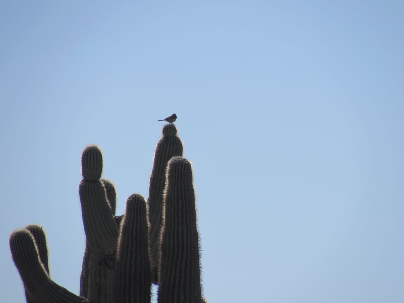
One of the rare saguaros in this area

Thursday we walked west along the south rim of Senator Wash to a group of cairns, one of which was at the top of trail angling down into the wash. 
We had seen this trail on our way back from our hike on Saturday.  The trail goes down onto a hard-packed ledge that sits above the gravelled bottom of the wash.  The walls of the wash are pock-marked with little caves.
We followed the wash west, getting down into the gravel bottom.   There were a couple of tricky sections where  there were little 'waterfall' spots. 
Further out, we went back onto a hard-packed ledge.  Along this, we had to make a decision whether to follow a burro trail back up to the rim  of work our way back into the gravel bottom to get to a point where the wash from Hess Mine comes into Senator Wash.  We chose to go down, and shortly got to the confluence of the washes.  We went into Hess Wash to look for a place to get back up on the mesa, as we didn't want to follow it all the way to where Hess Road goes into the wash.  We could see an ATV track going up over the rim. 

Before taking it, we sat for a few minutes for a snack.  We can see following Senator Wash further west on another stay, by driving out on Hess Road to where we came out of the wash here.  

Red-winged blackbirds in the desert