Thursday 28 March 2019

Week ending Mar 28, 2019 Laughlin


We forgot to mention an incident in last week's blog.   As we came to the lights in Parker on Wednesday, a 5th wheel was stopped in the left lane.  It's gooseneck had come off the hitch, and crashed through the tailgate. The trailer was 'kneeling' on the raised jacks on the front edge.  It looked like it must have happened recently, but would take a while to get it moved off the road.   It would have been interesting to know whether hitch broke, or didn't get hooked up correctly.  Seeing this makes us double check our hitch.

Thursday, we did the 2 mile each way riverwalk along the casinos.  We got a couple of ideas of places to eat before we leave.  

Friday we walked up to the top level of the RV park.  On that level we saw a motorcoach which was totally burnt out. It was a good thing that it was on a double sized site.  
burnt out motorcoach
On our way back down, we had a discussion with a couple about the Alberta spring election.  Since they won't be back until after the election, they had arranged to get a mail-in ballot.  Our plan is to arrive back in Alberta the day before the election. 

Saturday morning, we walked across the river, and were planning to walk along the Arizona side until we found that it looked like it was 'homeless' village, with a few tents and clothes around, so we gave it a pass.  We came back to the Nevada side, and looked up a Bank of America ATM. It looked like it was in the Tropicana Casino Hotel, so we headed there. While we were discussing where it might be with a lady working at the BBQ place on the corner, we checked its location on the phone, and found it was a couple of blocks north.  It turned out the address was the Laughlin Outlet Mall, so we checked out the directory which showed an ATM by the escalator.  It turned out to be on the back wall of the escalator.   There were a lot of closed stores in the mall, and many empty locations.   While we were walking the few blocks back to the RV park, we could see smoke along the road ahead.   When we got to the entrance to the park, we could tell that it was a vehicle burning.  We had time to go into the park, and into the casino parkade on the corner to get to the 'plus 15' walkway across to the casino, where we could see it fully engulfed.   A security officer told us she had called 911 to report the fire.  A few minutes later the fire trucks arrived and put out the fire.    Somebody was sure having a bad day.   
pickup burning
fire dept putting out the fire
We asked the officer about the motorcoach in the RV park that was burnt.  She said that happened at 3AM Monday morning.  No one was injured, and since they were in the double sites at the top, there was only minor blistering of vinyl on the adjacent RVs.    

Sunday, a fellow Titanium owner from Alberta came over to chat.

On Monday, we went into Bullhead City to pick up some groceries. Did laundry.

Tuesday we drove to Chloride, about 10 miles north of Kingman.  It looks like artists and collectors have taken over this old mining town.
one artistic yard
We stopped at Visitor Info, which is in the general store.  They recommended that we walk the 1.3 miles from the west edge of main (Tennessee) street to the Murals.  There were signs indicating which direction to take where there was any doubt. 
first direction sign to Murals
The murals are quite impressive. 
They were painted adjacent to some faint petroglyphs.
petroglyphs
  On the way back, we chatted with a couple from Alberta who had stopped their jeep at one of the junctions.  They told us they were boondocking on a vacant lot in town.  We expected a big motorhome, but when we got back to town, we noticed an old short schoolbus converted to a camper.  After eating the lunch we brought with us, we picked up ice cream treats at the store.    On the way back, we drove by the Mineral Park Mine, which has quite large tailings piles.
Mineral Park tailings
There were a lot of mines along the Cerbat range that runs northwest from Kingman. 

Wednesday, we walked out along the walking paths towards the Davis Dam at the north end of town.  We took the route to the Davis Dam lookout, a nice climb along the Horseshoe Loop to the top of a little hill along the river.  From there we could also see back to the casinos in Laughlin.  
Davis Dam
Laughlin
On the hitching rail at the lookout there was a sticker with the instagram #rnrseetheworld.  This instagram account is associated with the Whitecourt (Alberta) Wolverines, and is related to the deaths of the stepsons, Ryder and Radek, of the the team owner.

There were lots of a flower we haven't seen often.
Dune Evening Primroses (the white flowers)
Thursday, we took a different route toward the dam, up the Desert Trail.  It climbs up on the south side of the highway that goes west from Laughlin, ducks under the highway through a concrete underpass, then downhill toward the dam, coming out close to the overlook yesterday, then returns back along the river, about 5 miles.

Thursday 21 March 2019

Week ending Mar 21, 2019 Quartzite to Laughlin

On Friday, we picked up a few items in Quartzite before heading out about 6 rough miles from the highway, with 15 mph being about the best we could do into KOFA refuge to Crystal Hill.    It is a little hill with a lot of quartz on it.  It is the only area in the refuge where rock collecting is allowed.  There were several vehicles in the campground loop, without a camping unit, so we figure they were 'rockhounds'.  However, only 10 pieces up to 10 pounds total can be collected by a person in a year.  Digging and metal detectors are not allowed.  This was the closest parking to Livingston Mine, about 3 miles away.  We followed the 'roads', roughly around Crystal Hill to the mine, taking a couple of shortcuts over small shoulders.  The mine had a horizontal shaft into the side of the hill that looked at least 50 feet as far as the light went.  Given that snakes might be getting more active at this time of year, we didn't explore inside.
Entrance to Livingston Mine
Closeup
On a level higher than the shaft we found a couple of rock towers along a wall. 
 
Only one piece of equipment was left with KEEP OUT painted on it along with the name Joe Livingston.   We couldn't find any info for Joe Livingston.

Along the way back we found these really tiny flowers.
Tiny flowers

Saturday morning, we drove west from Quartzite to Blythe, CA, then north to the Midland LTVA.  We are thinking of getting the winter season pass for the LTVA which entitles us to go to about 7 different LTVAs on both sides of the Colorado River valley.   It looks like an okay area to camp, but we need to see if there is any hiking opportunities there.  From there we drove up to Parker through the Colorado River Indian Tribes Reservation.  They have quite a bit of acreage for growing hay crops.   We went to Walmart and Safeway to find both flavors of our iced coffee and pick up a few other things before returning to Quartzite and watching the end of the Canada Korean women's curling match.

Sunday we watched curling and Nascar, and John applied some Carnu-B protectant to the decals on the south side.  Interesting process, as it seems to dissolve some of the paint from the decals, which can then be put in to darken the weathering cracks in the decal.  Noticed that because even after cleaning the area, the sponge being used to apply the creme changed to the color of the decal.

Monday, we dumped the tanks, and took recycling to the county landfill.

Tuesday, we drove along the route we walked the first day we were here, then walked 3 miles further to the opposite end of the hill.
Flowers

Wednesday, we packed up and headed north.  Our first stop was for groceries in Parker, then for lunch at Red Robin in Lake Havasu City.  That break got us into Riverside RV in Laughlin about 1:30, about half an hour after they allow check-in.  We squeezed into our site, parked about 3 feet in front of the front window of the motorhome behind us, leaving just enough room for the truck in front of the trailer.  That was good, because the people next to us had to park their car between their motorhome and our truck.   This is one of those parks where the utilities are between two units, a trailer facing the street, and a motorhome facing into the site (which is why the motorhome behind us is right behind our back window.   But the price is right (us$120 for a week), and includes a buffet for two at the casino. Longer term sites are bigger here, but since we don't book much ahead, we don't get the bigger sites.

On Thursday, we went over to the Colorado River and walked the 2 miles down the riverside walkway, and back.

Thursday 14 March 2019

Week ending Mar 14, 2019 Quartzite


When we checked into the LTVA on Thursday Mar 7, they marked our two week departure date as 03/20.  When I said 14 days should be the 21st, they pointed out the chart on the wall that said that departure date from the 7th was the 20th.  I said that meant we didn't get 14 nights, but 14 days.  They agreed that was what it meant.   Government math I guess.

On Friday, we walked up an ATV trail across from our campsite, heading ESE toward a hill.  About 2/3 mi we encountered the end of LTVA sign (day use only area).  There were a few campers in the LTVA near the boundary, but lots of space.  About half a mile further, a woman in a pickup stopped to chat with us.  She has been camped up near the dumpster and toilets, and finds it a bit crowded there, so she was looking for a quieter spot.   We pointed out that she was past the limit.  She hadn't noticed the sign as she was admiring the saguaro as she drove out.  A few ATVs headed out while we were chatting. After that we only saw one other vehicle by the time we started heading back at  2.5 mile, which put us just across from the edge of the hill, with another 2.5 mi to get to the east side of the hill.  On the way back, we walked down a wash for most of the way until we got back to the LTVA boundary.  There were more flowers and birds and even a few lizards there than near the road. 

On Saturday morning, we drove into Quartzite, then east on I-10 to the next exit, Gold Nugget Mine Road.  We parked near the exit, and walked the 1.2 miles to the mine area.
Filament flowers

Wandered around looking at a few digs, shafts, old buildings, etc.  This appears to be one of the more recent mines, based on the type of structures, and the equipment over one of the deep shafts. 

We had a short chat with 2 couples from Alberta who were exploring the area in a Jeep

Sunday we ran the generator for a while so we could run the furnace (this continued almost every day this week).  About 50F in the morning inside.   Then we went for a 2 mi one-way walk  past the south boundary of the LTVA.  Pretty flat area.   Then Brier finals and Nascar race.

Monday morning, generator again.  We went into Quartzite, then east on Dome Rock Road to Mitchell Mine Road, south along it until we were 2 mi from Desert Queen Mine, a reasonable hike.  We walked up the road past a house in a little section carved out of the BLM area.  They had a sign on the edge of the road. 

The dogs barked at us but stayed in the yard area.  Beyond that we saw a couple of signs indicating private property, and directing us on the BLM route.  These looked like gravel processing areas.
small hoist
A section of the hill was covered in the little purple flowers we see everywhere. 
purple flowers across hill
Once past the second area, which had a large pit where the road used to be, we went into a pocket in the hills where Desert Queen is located.  We saw a tailings pile on a hill to our left, but DQ was supposed to be in a notch to the right.  We saw a couple of concrete structures,  a couple of older slabs, and one new looking structure that still had the wood forms along one side.  It had an inscription carved in the concrete,  Peter Jul 17,1981 so fairly recent.   Further along we came to an older cabin, and a three grave cemetery on a slope above it.  
 signs pointing to Penticton and Edmonds,Wa
somebody funny added the boots
From that site, we climbed up a road carved along the edge of a hill, and came to shoulder were we could look down on the gravel pit areas, and out to Quartzite.   We returned back along the road, and climbed up to the tailings on the edge of a hill.  There was only a shallow excavation in the middle of the top of the tailings.   However, from here, we could see where we missed the road up to the Desert Queen Mine location.  It didn't look like there is much there, and we were past the road in, so we continued back to our truck.   Today was very overcast, and when we got back to the trailer we got a bit of a sprinkle. 

It rained overnight, and well into Tuesday, finally breaking up around noon.
We drove into Quartzite to pick up a few things.  It is getting toward the end of the season, so most of the vendors in the marketplace were closed.  

Tuesday night was windy, so weather change coming.  Wednesday, we went for a 6 mi walk to check out 3 mines about 6 miles southwest of Quartzite.  On the way out we saw a small dig, with a memorial for Steven Grooms.

The first mine was Gold Eye Mine at the base of La Cholla Mountain.  The site is still active, with a trailer and equipment there, a fellow loading a utility trailer and lots of keep out signs.  However, on the edge of the mine is the old mine cabin, and a memorial and headstone for Lehre Harold Erdman.
Mine Cabin
A site with more pictures of the cabin.
There is also the remnants of a tall hoist structure.
 
Hoist over shaft
From there, we headed around the base of the mountain to Yellow Dog Mine, also marked as an active mine. 
Yellow Dog Mine
Further out toward the plain is a small hill with the Yum-Yum Mine on the top.  It was a bit of a scramble to get up, as they dumped a lot of uneven tailings from the two large shafts going into the hill near the top.   There was a nice little wren singing on a rock on the hill.
Shafts into Yum-Yum Mine
Cactus Wren
We could see back to La Cholla Mountain with the two mines we had just visited.
La Cholla Mtn - Yellow Dog on left,  Gold Eye on right
Back in Quartzite, since we had only had a carrot each for lunch, we picked up a couple of shamrock shakes at McDs.

When we got back to the trailer, we found that the strong northwest wind had pushed the solar panels at different angles, even though they are held by a chain with an 8x8x8 concrete block at each end. 

Thursday 7 March 2019

Week ending Mar 6, 2019 American Girl Mine Road Boondocking

It was nice to find that the Verizon wifi  boondocking here on American Girl Mine Road is much faster than it was in the RV park in Yuma. 

Friday morning, we got the controller working by disconnecting it from the batteries, and then reconnecting it.  It's a mystery why it thought the battery voltage was dangerously low, but good that a simple 'reboot' cleared the message.  Doesn't look like we will get a lot of solar power on a cloudy day, but the generator needs to pay for the maintenance we did on it.

We went for a hike from our trailer to Cargo Mine, tucked into a little pocket in the hills a few miles south of American Girl Mine.   Our topo gps map showed it was about 3.6 miles, so we decided that was within our range.  We aren't parked as close to the hills as we could be, since the Verizon signal starts to drop off closer.  The first half of the trip is through the boondockers. Then it heads into the hills, where we didn't see anyone for quite a while.  Then we saw 2 jeeps that were heading back from a side road toward the road climbing into the mine.  They just drove up a side road nearer the mine, because there is a gate across the road into the mine.   We don't think they even got out of there jeeps.  We had a short chat with the lead driver.  The Cargo Mine isn't on the scale of American Girl, but still has a decent tailings pile.  The color of these tailings was more pinkish orange than most.  An interesting feature was a couple of  small water reservoirs. 
Cargo Mine Tailings
Water Cistern
On the way here, we had taken a shortcut off the marked road routes (still on roads though), but they went through some fairly sharp washes.  On our return we kept on the main road, which went a bit further, but only crossed small washes until it hit the powerline road.   The powerline road has better grades crossing the deep washes.   When we got back to the trailer, we found we had both sunburned our shoulders, so were a bit uncomfortable.
  
We managed to get enough solar that we didn't need to run the generator.  We were only able to stay awake for the first half of the Brier wild card match, but we watched the end of it on the early Saturday morning rerun.

Then we went for a shorter walk.  It was pretty overcast early in the morning, but we were still surprised to see a faint rainbow.  We did get a few sprinkles.  We walked over to the first hill we had climbed here a few weeks ago.   Later when we went out to the American Girl Mine, we had noticed a structure on the side of the hill opposite to where we had climbed, so we checked out that area this trip.  Only a 2.5 mile trip, but still some exercise.   On the way back, we were chatting with a fellow walking his dog.   He has been to all of the mines around here over the years.   We mentioned our experience at KOFA mine last year, and that the new owner was planning on turning it over to the wildlife refuge after getting it cleaned up.   That got this fellow going about how some refuges keep people out.   According to the constitution, public lands are for the use of the people, so they can't stop him from using them.
Old structure
It started clearing off late morning, so our solar could get to work.  Watched the opening game of the MLS season, with Toronto beating Philadelphia, before watching the opening round of the Brier, more MLS with Vancouver and then the second round of the Brier. 

Sunday, after a bit of curling, we did about 3 miles in the general direction of a mine we could see a bit north of American Girl Mine.  We marked a spot along the power line that looked like it would be a good place to park and explore further tomorrow.   Then Nascar and curling.   Good solar.

Monday morning, we drove the truck along the power line road a bit further north than we had marked to the beginning of a BLM road that clearly headed toward our target mine. The walk was pretty level, with only a couple of shallow washes. 
BLM road into south side of Tumco Mine
The mine is tucked behind a small slot in the hills, but it turns out it is open on the side facing Tumco.  Before we came out here when we were planning at camping at Tumco, John had plotted out a 5.2 mile hike on a loop that started at Tumco, followed a road into the hills, then continued back out of the hills toward the powerline road, then returned to Tumco along the powerline.   It turned out that we had followed the second leg, coming out of the hills, to get to this mine site, so in theory we should have been able to go down the other side into Tumco.   The road on the topo map would have had to go over the top of the big tailings pile on which we stood to look down over the Tumco camping area.  We didn't think there was a decent route down in that direction.  However, we plan to drive into Tumco tomorrow, as we can get into the pit of the mine from that side.   Maybe from there we will see where the 'road' goes over this mine.  Unfortunately, there is no indication whether this is the actual Tumco mine but based on its location and size, it must be.  It isn't as large as AMG Mine, but a sizeable fraction.
Entrance to mine tunnel welded shut
tunnel
open pit area of the mine
natural patterns on rock walls
The mine is in the gap between 1080 foot hill and a 1680 foot hill.   The plain around is about 520 feet above sea level.

On the way back down from the mine, John was checking whether a bypass around a steep section of the road was feasible when he jumped suddenly back onto the road. He had caught the movement of a reptile out of the corner of his eye. It turned out to be on of the largest lizards we have seen in the desert here. Most of the geckos are only about 2 to 3 inches long.  This one was at least 5 times as large.
largish lizard
butterfly
Joan found a fun fact today.  If the current population of the world all lived at the same density as the population of New York City, they would fit in a space the size of Texas.


On Tuesday, we drove 4 miles north on the highway to the Tumco townsite.   This time, we walked past the interpretive trail, along the side of the hill, seeing a few graves on a rise,
crosses
and a few more buildings, and a well covered shaft.   From there we crossed a wash to the lip of the Tumco pit, on the opposite side we had been yesterday.   We found a route down into the pit with only a few short spots with iffy footing.    Despite the fact that they had excavated huge quantities of rock from the pit, there was still a small shaft, maybe 3 feet high, running into one of the walls, where they must have found a good vein of minerals.
Tumco pit from north rim

3 foot high shaft into wall of pit


Wednesday, after watching the first Brier draw, and having lunch, we drove back to the Tumco area, but this time we headed west on the plain to the 
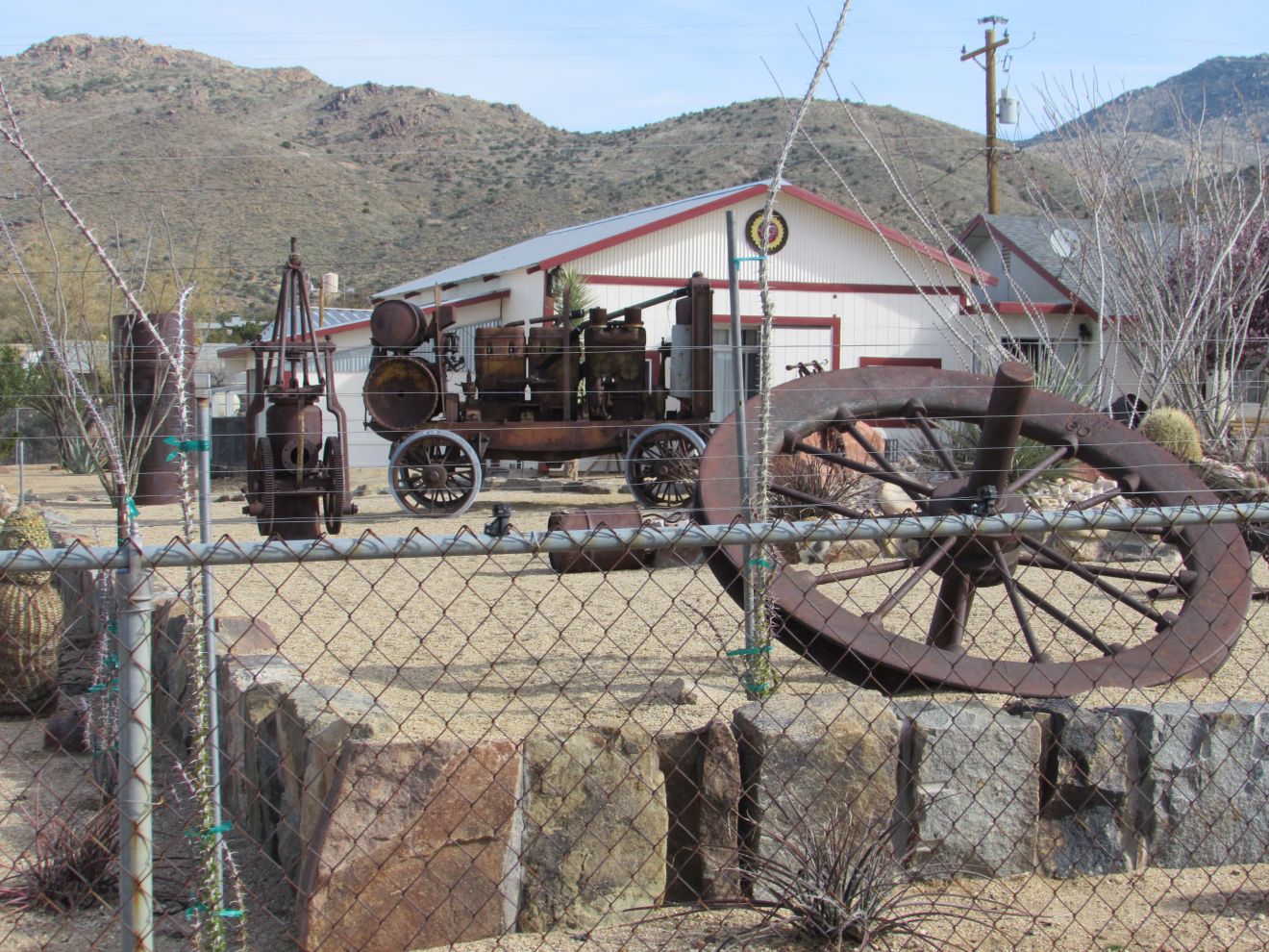
Gold Rock Ranch RV Resort.  A fellow we encountered had told us we should check it out.  In addition to the RV park, they have a small museum of mining information and artifacts from Tumco, an collection of antiques and a variety of rocks for sale.  We were pleased to see they had some ice cream, as well as water and popcorn.   We had long chats with two of the people operating the park.
fountain
Gold Rock Ranch
Thursday we headed north on County Road S34 north Highway 78, and on to Blythe, CA where I-10 crosses back into Arizona.   After picking up some groceries, we headed to Quartzite to spend a couple of weeks in the BLM long-term visitor area (LTVA).   No hook-ups here, but a step above boondocking since there is water and sewer dumps available for $40 ($180 for the whole winter if you want to stay that long).